- 1.1. Mandate of the Independent Review
- 1.2. Methodology
- 1.2.1. Task #1 – Stakeholder Engagement
- 1.2.2. Task #2 – Impact of the Act on Technological Development and Impact of Technological Development on the Relevance of the Act
- 1.2.3. Task #3 – Canada’s International Obligations
- 2.1. Responses to the Stakeholder Questionnaire
- 2.1.1. Breakdown of Stakeholders Who Responded to the Questionnaire
- 2.1.2. Stakeholders’ Knowledge of the RSSSA
- 2.1.3. Response to the Policy Goals of the RSSSA
- 2.1.4. Facilitating Industry
- 2.1.5. Issues Surrounding Data
- 2.1.6. The RSSSA and Canada’s International Obligations
- 2.1.7. Administration of the RSSSA
- 2.1.8. Other Issues Related to the RSSSA
- 2.2.1. RSSSA Provides a Generally Workable Regulatory Scheme
- 2.2.2. Adverse Impact on some Space Businesses and Research Groups
- 2.2.3. Impact of RSSSA on Industry is Poorly Understood
- 4.1. Large Constellations of Satellites
- 4.2. Small Satellites
- 4.3. More and Cheaper Space Launch
- 4.4. New Operational Concepts
- 4.5. Innovation in Sensors
- 4.5.1. Radar Sensors
- 4.5.2. Optical Sensors
- 4.5.3. Impact of Sensor Innovations
- 5.1. Impact of the RSSSA on Research and Development
- 5.2. Impact of the RSSSA on Space Remote Sensing Businesses
- 5.3. Impact of the RSSSA on Innovation in the Use of Remote Sensing Space Data
- 6.1. Data Controls
- 6.2. Privacy
- 6.3. Big Data
- 6.4. Technology Summary
- 7.1. The Evolution of Canadian Space Governance
- 7.2. RSSSA Plays a Unique Role in Canadian Space Governance
- 7.3. Exempting the Crown from the RSSSA
- 7.4. Impact of the RSSSA within Canada’s Space Governance Patchwork
- 7.4.1. Security Issues Dominate Decision-making
- 7.4.2. Unintended Barriers to Entry for R&D and Business
- 7.4.3. RSSSA Versus Initiatives for Open Government
- 8.1. Binding International Space Obligations
- 8.1.1. UN Treaties and Conventions
- 8.1.2. Canada-U.S. Agreement Concerning Commercial Remote Sensing Satellite Systems (2000)
- 8.2.1. Principles Relating to Remote Sensing of the Earth from Outer Space (1986)
- 8.2.2. IADC Debris Mitigation Guidelines (2007)
- 8.2.3. UN Long Term Sustainability Guidelines (2019)
- 8.2.4. UN General Assembly Resolution 75/36 on Reducing space threats through norms, rules and principles of responsible behaviours (2020)
- 8.2.5. The Disaster Charter
- 9.1. United States
- 9.2. Japan
- 9.3. Germany
- 10.1. GAC’s RSSSA Organization
- 10.2. Current Regulatory Practice
- 10.3. Interdepartmental Support of the RSSSA Licensing Process
- 10.4. Ongoing Improvements in Regulatory Practice
- 10.5. Other Avenues for Improvement
- 10.5.1 Public Outreach, Including a Permanent Advisory Committee
- 10.5.2 Improvements to the RSSSA Licence Application Process
- 11.1. Operation of the RSSSA
- 11.2. Administration of the RSSSA
- 11.3. Canadian Space Governance
- 11.4. Emerging Regulatory Issues
- 12.1. Short-Term Recommendations
- 12.2. Medium-Term Recommendations
- 12.3. Long-Term Recommendations
- Annex A - Replies to the RSSSA Stakeholder Questionnaire
- Annex B - Technology Trends for Earth Observation
- Annex C - Existing and Near-term Earth Observation System
- Annex D - Documents used in the Independent Reviews
List of Figures
- Figure 1 - RSSSA Costs to Industry Should Not Be Discounted
- Figure 2 - Disparate Government Actions Fail to Support Innovation
- Figure 3 - Number of Stakeholder Questionnaire Replies by Stakeholder Type
- Figure 4 - RSSSA Complicates Using the Cloud
- Figure 5 - Controls Required by RSSSA Complicate Access to Canadian Data
- Figure 6 - Earth Observation Satellite Launches by Year
- Figure 7 - Canadian Space-Related Legislation
- Figure 8 - RSSSA Limits Use of Canadian Ground Stations
- Figure 9 - U.K. Licence Screening Tool
List of Tables
- Table 1 - Relevant Attributes of Key Earth Observation Constellations
- Table 2 - Some Classes of SmallSats
- Table 3 - Satellite Altitude and Natural Lifetime
Executive Summary
Canada is at a crossroads in its regulation of remote sensing space systems. The Remote Sensing Space Systems Act (RSSSA) and its Regulations once served an important security purpose but are now being rendered increasingly irrelevant by the rapid march of satellite and remote sensing technology and by a new reality of widely available commercial remote sensing space data that covers our planet.
While international competitors and allies, especially the United States, are relaxing their regulation of remote sensing space systems in response to changes in space technology, the Government of Canada, through Global Affairs Canada (GAC), continues to closely regulate such systems under the RSSSA. The resulting regulatory burden imposed on the Canadian remote sensing space industry and research and development (R&D) groups is hindering Canada’s participation in today’s global space revolution. Without significant reform of its space regulations in general and the RSSSA specifically, and despite its rich heritage in space, Canada risks falling behind other nations in realizing the myriad opportunities that space systems can provide here on Earth to grow the economy, help save the environment, and support northern, indigenous, and other Canadian communities.
The government staff implementing the RSSSA at GAC have done excellent, under-recognized work in recent years to improve the operation of the Act. GAC’s initiatives include a new client procedures circular, an Ad Hoc advisory committee with members from industry and academia, and other outreach activities that have broadened the understanding among stakeholders of the purpose and functioning of the RSSSA and improved the licencing process.
Nevertheless, the existence of a rapidly growing, lightly regulated global commercial marketplace of space remote sensing information makes the Canadian regulatory framework – which places strict controls on approximately two dozen remote sensing space systems Footnote 1 . within a global marketplace served by hundreds of international remote sensing satellites – less relevant by the day. Many in the Canadian remote sensing space industry, including large established companies that gave carefully considered inputs to the Independent Review, are frustrated by increasingly irrelevant regulatory requirements placed on them by the RSSSA.
Figure 1 highlights concerns about costs for industry caused by the Act. Some companies report that business opportunities have been abandoned in the face of RSSSA licencing requirements.
Figure 1: RSSSA Costs to Industry Should Not be Discounted (Nine of twenty-one respondents (43%) report costs are Significant or Prohibitive)
Text version
LONG DESCRIPTION: Figure 1 shows the number of responses to Question 22 of the Stakeholder Survey on the Incremental costs to industry imposed by the RSSSA:
- Negligible: 3 out of 21
- Minor: 9 out of 21
- Significant: 5 out of 21
- Prohibitive: 4 out of 21
More broadly, the RSSSA should be just one part of a coherent, coordinated, and overarching framework of government oversight and support to Canada’s space industry, as that industry delivers the promise of space to all Canadians. However, that framework simply does not exist. Instead, Canada’s space innovators must navigate a complex and disjointed puzzle of regulatory oversight, industrial support programs, and fragmented government priorities (e.g., RSSSA, spectrum licencing, cybersecurity, satellite registration, launch regulation, industrial promotion, federal procurement). At times, the different elements of this puzzle may even work at cross-purposes to one another (e.g., Case Study Figure 2).
Figure 2: Disparate Government Actions Fail to Support Innovation Footnote 2
Case Study - Disparate Government Actions - Fail to Support a Canadian Space Innovator
- A Canadian innovator develops new space-based technology.
- Data produced might be sensitive in some eyes but is not a clear case of “sensing the surface of the Earth” that would oblige application of RSSSA.
- Nevertheless, the Canadian regulator requires system to be licensed, prioritizing potential security concerns over economic development.
- Licensing adds some cost, complexity, and uncertainty for the company. (Its RSSSA licence remains provisional to this day.)
- Meanwhile, a global marketplace develops for this type of data as a commercial commodity available from many international space systems.
- Other elements of Government buy a similar lower-cost service from international providers, failing to support Canadian innovation.
- As a result, a Canadian space innovator is disadvantaged in the global market by the disparate actions of the Government of Canada and opportunities for Canadian economic development are lost.
Given that Canada lacks a Space Governance Framework, the RSSSA is one of the only pieces of Canadian legislation that directly governs space activities. Footnote 3 Other government priorities, such as promoting economic prosperity, may not be well enough expressed in policy or implemented in legislation to properly impact regulatory and other government decision-making about space. As such, the security concerns that gave rise to the RSSSA some twenty years ago tend to have outsized influence today, given their place as part of an established regulatory regime.
Specifically, when it entered into force in 2007, the RSSSA was an appropriate and useful regulatory response to the emergence of unique commercial space remote sensing capabilities, such as Radarsat-2, that began to rival the highly classified national security capabilities of the advanced space powers. The RSSSA provided the government with tools to ensure that data from such systems would not endanger Canada’s security. It was also true that some companies welcomed the introduction of a framework that ensured their innovative activities in space were legitimate and correct from a government perspective. The primary security focus of the Act was necessary, clear, and effective.
However, technological developments in the intervening years, especially the launch of hundreds of remote sensing satellites from countries around the world, have turned most commercial space remote sensing information into a business commodity, widely available from a large and growing range of global sources. Information from systems like Radarsat-2 and its successors is no longer unique or special, and controlling the small number of Canadian licenced systems provides little policy benefit in the face of a flood of similar international data.
For example, “the safety of Canadian Forces” must be considered when the Minister issues a licence under the RSSSA. However, today’s reality is that Canadian Forces must adapt their operational plans, and Tactics, Techniques, and Procedures (TTPs) to account for their near constant exposure to surveillance from hundreds of remote sensing satellites. The RSSSA’s ability to exercise some control over Canadian remote sensing space systems – that are a very small subset of the global collection of such systems – is of minimal operational value to Canadian Forces. Similar analysis applies to other security and foreign policy goals of the RSSSA: the controls provided by the Act are of limited practical use in today’s world of ubiquitous space remote sensing.
Yet, the existing provisions of the RSSSA require that the Canadian regulator continue to prioritize potential security concerns about the remote sensing space systems of Canadian operators and those of foreign operators in Canada. This security focus can introduce incremental costs and operational complications for Canadian space innovators. Various other priorities (e.g., research and development of space systems, economic development for all Canadians enabled by space systems, support to Northern communities) can languish in competition with the established security imperative of the RSSSA.
From a broader perspective that includes Canada’s science, innovation, and economic goals, in addition to security concerns, the opportunity costs of the RSSSA now outweigh the security benefits provided by the Act.
In the short term, concrete practical steps are needed to formally review and, as much as possible, adjust how the security and foreign policy goals of the RSSSA are assessed and implemented in the practical operation of the Act. GAC should lead a formal interdepartmental review of the policy goals of the RSSSA to balance and reconcile Canadian national security and foreign policy interests with the economic development, innovation, and global competitiveness interests of the country.
In the longer term, Canada needs new legislation and regulations that position Canadian industry to compete from a position of strength and agility in today and tomorrow's global space market.
Our complete list of 11 short, medium, and long-term recommendations are found in Section 12 of this report.
Key Findings
- Impact of the RSSSA on Technological Development – The RSSSA inhibits technological development of remote sensing space systems in Canada, including by regulating such systems more strictly than other international jurisdictions, especially the United States. Canada is therefore becoming a less desirable place to conduct space remote sensing research and development, grow space remote sensing businesses, and exploit space systems to address global challenges like climate change.
- Impact of Technological Development on the RSSSA – Recent technological development of commercial remote sensing space systems, especially the global proliferation of large numbers of such systems, calls into question the need for the security controls (e.g., Customer Access Profiles, Shutter Control) on Canadian remote sensing space systems and those of foreign operators in Canada that are imposed under the RSSSA. Such controls can now be safely reduced.
- Impact of the RSSSA on the implementation of international agreements and treaties – Canada is meeting its international obligations with respect to remote sensing space systems, in part through the provisions of the RSSSA.
We further highlight that:
- The RSSSA has been an effective tool to mitigate the risks to Canada’s security and foreign policy interests that were identified when the Act was created some twenty years ago.
- Report Section 2.2.1 – RSSSA Provides a Generally Workable Regulatory Scheme
- Report Section 3 – Original Context and Purpose of the RSSSA
- Report Section 4 – Technological Development and the Current Context for the RSSSA
- Report Section 2.2 – Adverse Impact on some Space Businesses and Research Groups
- Report Section 2.2.3 – Impact of RSSSA on Industry is Poorly Understood
- Report Section 1 – Comparisons with other International Space Remote Sensing Regulations: United States
- Report Section 12 – Recommendations
1. Introduction
Canada’s Remote Sensing Space Systems Act (RSSSA) entered into force in 2007 to regulate new, unique, and highly capable Canadian Earth observation satellites like Radarsat-2. In the wrong hands, data from such satellites could have harmed Canadian interests. In close coordination with allies such as the United States, the Government of Canada implemented the RSSSA to mitigate that risk of harm to Canadian interests.
In the intervening years, the technology, business, and international regulation of remote sensing space systems have changed significantly. Hundreds of very capable remote sensing satellites have been launched by countries around the world. Data from Canadian remote sensing space systems is no longer unique or special. Instead, space remote sensing data is now a commonplace commercial commodity widely available from many sources with few restrictions.
As a result, Canada’s use of the RSSSA to limit the distribution of Canadian remote sensing space data is now arguably of questionable value since customers around the world can easily obtain equivalent data from multiple other sources. Governments, militaries, and others who may have used tools similar to the RSSSA to control information about their operations derived from remote sensing satellites, have been forced to adjust to a new reality of ever-present surveillance from space that they largely cannot control. Of note, the United States liberalized its space remote sensing regulations in 2020 and now prioritizes support for the U.S. space remote sensing industry in its regulations rather than the pursuit of largely unachievable security goals.
In Canada, the RSSSA and its implementing Regulations have not changed since coming into force in 2007. The Canadian regulator (GAC) must still apply specific security and foreign policy criteria to the licensing of government and commercial remote sensing space systems operated by Canadian operators worldwide and by foreign operators in Canada. The resulting regulatory requirements continue to add cost and complexity to Canadian systems and put Canadian industry at an international competitive disadvantage.
Fortunately, the RSSSA anticipates the dynamic nature of space remote sensing technology and mandates that an Independent Review of the Act be conducted every five years.
This 2022 Independent Review of the RSSSA, conducted on the fifteen-year anniversary of the Act coming into force, addresses the significant changes in space remote sensing technologies and policies since 2007 and makes recommendations to ensure the Act and related policies continue to serve Canada’s best interests into the future.
1.1. Mandate of the Independent Review
The requirement to conduct periodic Independent Reviews of the RSSSA is contained in Section 45.1 of the Act, which calls for:
“… an independent review of the provisions and operation of the Act to assess, in particular, its impact on technological development and on the implementation of international agreements and treaties.”
Independent Reviews must be conducted every five years. Previous reviews took place in 2012 and 2017 and were ably conducted by the McGill University Institute of Air and Space Law.
SSCL is conducting the 2022 Independent Review of the RSSSA under the terms of contract # 7427285 with GAC. The Statement of Work for that contract describes three tasks:
- Task #1: Undertake an extensive consultation of key stakeholders (industry, academia, and government) to inform the Review.
- Task #2: Undertake an examination of:
- the impact of the Act on technological development and
- the impact of technological developments on the relevance of the Act, whether technological developments have rendered any aspects of the Act out of date and what, if any, amendments to the Act and/or Regulations may be needed to reflect technological development.
The contract also requires that the final report of the Independent Review not disclose the names of those consulted or interviewed. This anonymized approach to the final report facilitates full and frank inputs from the RSSSA stakeholders consulted by the Review team.
1.2 Methodology
SSCL conducted the three tasks required by its Statement of Work as follows:
1.2.1. Task #1 – Stakeholder Engagement
GAC provided SSCL with a list of recommended stakeholders for the Review team to consult. SSCL updated and expanded that list.
SSCL analyzed the current issues associated with the RSSSA and created a comprehensive online Questionnaire to gather the views of RSSSA stakeholders on these issues.
SSCL emailed a total of 101 RSSSA stakeholders from industry, academia, and government, in Canada and abroad, inviting them to provide their inputs to the Independent Review via email or by completing the online Questionnaire. The Independent Review was also announced via a media release that was posted on the SSCL company website Footnote 4 and the company’s social media feeds and provided to a small number of Canadian space news websites. Of those websites, Space Q Canada Footnote 5 reported on the start of the Independent Review.
SSCL received inputs from 62 RSSSA stakeholders as follows:
- Generally brief, email-only exchanges with 18 stakeholders who provided some comments on the RSSSA but chose not to complete the online Questionnaire
- Questionnaire responses, with no other discussion, from 14 stakeholders
- Questionnaire responses and email discussions from:
- 20 individual stakeholders
- 3 stakeholder organizations - Each organization’s questionnaire response consolidated inputs from 3 individual stakeholders at each organization, i.e., 9 total individual stakeholders.
The Review team conducted follow-on interviews with 20 of the 62 RSSSA stakeholders who had provided initial input to the Independent Review. For the most part, the follow-on interviews were prompted by requests from stakeholders who wanted an opportunity to expand upon their initial replies to the Questionnaire. The Review team also initiated some interviews with certain stakeholders with particular expertise or a unique perspective on issues of interest to the Review team.
The results of the stakeholder consultations are provided below in Section 2 of this report.
1.2.2. Task #2 – Impact of the Act on Technological Development and Impact of Technological Development on the Relevance of the Act
There have been dramatic technological developments in satellites and remote sensing space systems over the 15-year life of the RSSSA. SSCL maintains an ongoing technology watch of these developments for a variety of purposes and clients. We have leveraged our existing knowledge base of these developments for this Review, conducted additional research in areas of specific interest for the RSSSA, and drawn on the results of the RSSSA stakeholder consultation to inform our analysis.
- Section 4 of this report provides an overview of the relevant technological developments and basic assessments of the immediate impact of those technological developments on the relevance and operation of the Act.
- Section 5 of this report assesses of the impact of the Act on the conduct of space remote sensing technological development (e.g., research and development (R&D), business development) in Canada.
- Section 6 of this report considers the broader and longer-term impact of technological development on the RSSSA and Canada’s overall space governance framework.
The Review team have been careful to draw only on publicly available information for the purposes of this unclassified Review to be tabled in Parliament.
1.2.3. Task #3 – Canada’s International Obligations
As noted in the previous Independent Reviews of the RSSSA conducted by the McGill University Institute of Air and Space Law in 2012 and 2017, there are only a handful of legally-binding international space obligations for Canada. We identified three UN treaties and conventions, plus one bilateral agreement between Canada and the US as sources of such binding obligations applicable to space remote sensing. These obligations tend to be loosely defined and Canada easily meets them.
Our analysis of international obligations for this Independent Review has, therefore, been a relatively straightforward confirmation of the findings of the previous Reviews, informed by our engagement with RSSSA stakeholders and other correspondence with Canadian and international space law and policy practitioners.
Our legal and policy team have also analyzed Canada’s compliance with several non-binding but still important international space governance resolutions, guidelines, and agreements.
The analysis of Canada’s compliance with international obligations associated with space remote sensing is found in Section 8 of this report.
2. Results of the Stakeholder Engagement
As described in the methodology section above (Section 1.2.1), the Independent Review team engaged with 62 RSSSA stakeholders from industry, academia, and government, in Canada and abroad. Our stakeholder engagements included email exchanges, receiving position papers, conducting an online stakeholder Questionnaire, and interviewing selected stakeholders.
The online RSSSA Stakeholder Questionnaire was a key part of our engagement strategy. We received 37 replies to the online Questionnaire. Those replies are summarized below and reported in detail in Annex A.
2.1. Responses to the Stakeholder Questionnaire
This summary of the responses to the Stakeholder Questionnaire follows the structure of the Questionnaire, which included the following nine sections:
- Introductory Questions
- Knowledge of the RSSSA
- Policy Goals of the RSSSA (including national security)
- Facilitating Industry
- Issues Surrounding Data
- The RSSSA and Canada's International Obligations
- Administration of the RSSSA
- Other Issues Related to the RSSSA (e.g., National Space Policy)
- Follow-on Communication with the Independent Review Team
The summary discussion below is anonymized – i.e., we do not provide any information, especially from “Introductory Questions”, that would identify individuals or organizations.
The summary focuses on Sections 2 through 8 of the Questionnaire that constitute the substantive portion of the survey.
Stakeholders were asked to reply only to those sections of the Questionnaire within their experience and expertise. As a result, there are different numbers of total replies for different sections of the Questionnaire, and the rough percentages provided in the discussion below are sometimes based on small numbers of replies to specific questions. These rough percentages are not the product of a rigorous statistical analysis and are only intended to give a general sense of the nature of the replies to the survey.
2.1.1. Breakdown of Stakeholders Who Responded to the Questionnaire
Respondents were asked what group of RSSSA stakeholders they represented. Those replies are summarized in Figure 3 below. The largest number of replies came from government stakeholders, followed by industry stakeholders.
Figure 3: Number of Stakeholder Questionnaire Replies by Stakeholder Type (Note that some stakeholders provided input outside the Questionnaire, e.g., via email)
Text version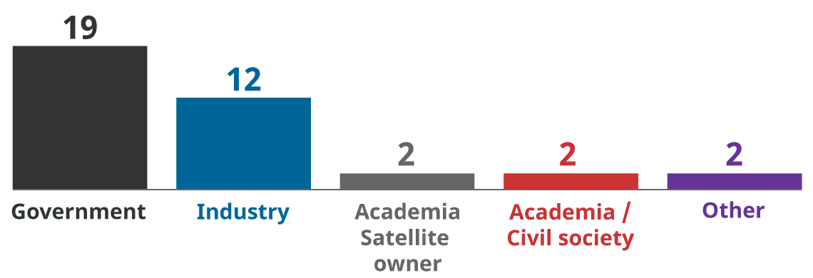
LONG DESCRIPTION: Figure 3 shows the following number of questionnaire replies by type of stakeholder:
- 19 from Government
- 12 from Industry
- 2 from Academia Satellite Owner
- 2 from Academia or Civil Society
- 2 from Other
It is notable that roughly half of the respondents to the questionnaire were government stakeholders. This large response from government stakeholders is likely because the RSSSA is a tool for government to regulate remote sensing space systems. The relevant government stakeholders contacted by the Review team were quite familiar with the RSSSA and willing to support a legislatively-mandated process to review the Act. Some of the government responders were also RSSSA licence holders.
Industry stakeholders, especially smaller organizations, tended to have less available time to participate in the Review and expressed some scepticism about the value of the Review. The larger, well-established space remote sensing companies tended to provide more substantive inputs to the Review versus small commercial start-ups or university R&D groups.
In any event, we must remain aware of the large portion of government stakeholders in the response numbers provided below and in Annex A to this report. For certain key questions where there was a notable difference in the replies from different stakeholder groups, e.g., understanding of the costs to industry imposed by the RSSSA (Section 2.1.4 below), the response is broken out by stakeholder group (i.e., government versus industry versus academia). Those raw numbers are provided in Annex A and summarized below.
2.1.2. Stakeholders’ Knowledge of the RSSSA
The stakeholders replying to the questionnaire were quite knowledgeable about the RSSSA.
- Over 86% (32 of 37) reported having “good”, “very good”, or “extensive” knowledge of the RSSSA.
- Just under 50% (18 of 37) said they or their organization had actively considered a potential application for a licence under the RSSSA.
- Just under 40% (14 of 37) had been granted a licence under the RSSSA.
- Some 27% (10 of 37) had been part of the government review of an RSSSA licence application.
2.1.3. Response to the Policy Goals of the RSSSA
The survey posed several general questions to gauge the support of respondents for the policy goals the RSSSA is intended to meet (e.g., protecting Canada’s national security and supporting foreign relations). The survey also asked stakeholders for their assessment of the value of the tools provided by the RSSSA – such as interruption of service (i.e., “shutter control”: restrictions on taking images of certain areas of the Earth) – in meeting the policy goals of the Act.
- Over 80% (22 of 27) of stakeholders who replied to the question supported the policy goals of the RSSSA.
- Less than 20% (5 of 27) of stakeholders who replied to the question “disagreed” (2) or “strongly disagreed” (3) with the policy goals of the RSSSA. The stakeholders who strongly disagreed with the policy goals of the RSSSA were from industry. One industry stakeholder who did not complete the questionnaire, but provided comments by email, strongly suggested that the policy purposes of the RSSSA were not legitimate.
- Stakeholders were divided on whether the controls provided under the RSSSA (i.e., Customer Access Profiles (CAPs), Shutter Control, Priority Access) are useful in achieving the policy goals of the Act. On average for the three types of controls, approximately 60% of stakeholders thought the controls were useful and 40% found them not useful.
- Almost 90% (23 of 26) of stakeholders who replied to the question thought some space remote sensing activities should be exempt from the RSSSA: “Strongly agree” (10), “Agree” (13).
2.1.4. Facilitating Industry
The survey contained eighteen questions to assess the impact of the RSSSA on Canada’s remote sensing space industry, such as: What incremental cost does the RSSSA create for industry? Do controls imposed under the RSSSA adversely impact businesses?
Thirty-one stakeholders responded to this section of the questionnaire, 16 from government and 15 from industry and academia.
- Some 74% (23 of 31) of stakeholders who replied to the question believed that the RSSSA creates incremental costs for industry.
- There was a wide range of opinions – from “negligible” to “prohibitive” – about the size of the incremental costs created by the RSSSA for industry and the nature of other impacts the RSSSA has on business. There was a difference of opinion on this issue between government and non-government stakeholders:
- Over 87% (14 of 16) of government stakeholders indicated that they either did not know the nature of the costs for industry caused by the RSSSA or that they believed such costs were low: “Don’t know” (8), “Negligible” (1), “Minor” (5).
- Over 45% (7 of 15) of non-government stakeholders (e.g., industry, university R&D groups) indicated that the incremental costs imposed by the RSSSA were an important issue, i.e., incremental costs were “significant” (4) or “prohibitive” (3).
A more detailed break-down of the responses by stakeholder type to key questions about the RSSSA’s impact on facilitating industry can be found in Annex A, questions 21-26.
2.1.5. Issues Surrounding Data
Controlling data from remote sensing space systems is an important function of the RSSSA. The survey explored whether the provisions of the Act supported the needs of business related to data handling, while also allowing for any controls on data handling required to meet the policy goals of the Act.
- Over 70% (15 of 21) of those who replied to the question reported that the data-related definitions in the Act are not well suited to their activities.
- Over 80% (17 of 21) of those who replied to the question thought the RSSSA had a “negative” (11) or “very negative” (6) impact on the ability of business to adopt modern data handling practices (e.g., cloud storage).
- Some 64% (16 of 25) of those who replied to the question believed the RSSSA was not well suited to implementing modern information protection techniques (e.g., data-centric security).
2.1.6. The RSSSA and Canada’s International Obligations
The Independent Review was specifically tasked to assess whether Canada meets its international obligations with respect to space remote sensing. The survey posed a small number of questions on this topic to supplement the Review team’s analysis of this issue.
- All but one of the stakeholders who replied to the question (22 of 23) believed that Canada meets its international obligations with respect to space remote sensing.
- While only one stakeholder thought Canada does not meet its international obligations with respect to remote sensing, two stakeholders commented during interviews that Canada meets its obligations despite gaps in the applicable regulatory frameworks, including the RSSSA. For example, Canada has implemented informal procedures to register its satellites in accordance with the UN Registration Convention, but there is no formal regulatory requirement for Canadian satellite operators to do so.
2.1.7. Administration of the RSSSA
The Stakeholder questionnaire included 15 questions concerning the administration of the RSSSA by Global Affairs Canada. Of note:
- Almost 81% (17 of 21) of those replying to the question understood what information is required in an RSSSA licence application.
- Almost 60% (12 of 21) of stakeholders who replied to the question reported that the process to apply for a licence under the RSSSA was not straightforward.
- There were mixed opinions about whether the licence approval process was clear, transparent, and timely.
- Almost 60% (12 of 21) of stakeholders who replied to the question “agreed” that the licence approval process was clear and transparent. Six stakeholders “disagreed.” Three stakeholders “strongly disagreed”.
- 60% (9 of 15) of stakeholders who replied to the question reported their licence under the RSSSA had not been issued in a timely fashion, with the remaining 40% reporting their licence was issued in a timely fashion.
2.1.8. Other Issues Related to the RSSSA
The RSSSA is related to other existing or potential Canadian space governance legislation and policies. The Questionnaire included a small number of questions about this broader space governance context.
- Canadian satellite operators must deal with several separate government departments and agencies (e.g., GAC for remote sensing space systems; Innovation, Science and Economic Development (ISED) for Radio Frequency spectrum; the Canadian Space Agency (CSA) for satellite registration) to operationalize their satellites. Almost 90% (17 out of 19) of stakeholders who replied to the question reported that having to deal with multiple government departments to license a remote sensing space system is “burdensome” (12) or “very burdensome” (5).
- Strong majorities of the stakeholders who replied to the applicable questions believe Canada needs comprehensive space legislation: 95% (20 of 21 respondents) and/or a national space policy: 79% (19 of 24 respondents).
- A common theme emerging in Questionnaire responses and during interviews with stakeholders was that any comprehensive Canadian space legislation or national space policy should provide for a “one-stop shop” for government licensing and support of the Canadian space industry.
2.2. Key Themes from the Stakeholder Engagement Identified by the Independent Review
The inputs the Review team received from our engagement with government, industry, and academic stakeholders confirmed our initial expectations: the ongoing dramatic changes in the technology, business, and international regulation of space remote sensing are having a significant impact on the space remote sensing activities regulated by the RSSSA. The purpose and functioning of the Act must be reassessed in light of those changes.
Three key themes emerged from our stakeholder engagement that informed our analysis of the impact of these changes on Canada’s space remote sensing regulatory framework:
- To date, the RSSSA has provided a generally workable regulatory framework for Canadian oversight of remote sensing space systems.
- The RSSSA is having increasing negative impacts on the development and operation of Canadian remote sensing space systems.
- The incremental costs that must be borne by industry to adhere to the RSSSA are not well understood, especially by stakeholders in government. This lack of understanding is significant since it is GAC, with the advice of other government departments, that must strike the appropriate balance in the operation of the Act between meeting Canada’s security and foreign policy goals and enhancing the competitiveness of Canada’s remote sensing space industry.
These three themes are further developed below.
2.2.1. RSSSA Provides a Generally Workable Regulatory Scheme
The RSSSA has functioned effectively since coming into force in 2007. Based on estimates provided by GAC Footnote 6 , nineteen Canadian remote sensing space systems received a licence or provisional approval under the RSSSA from 2007 to 2020, and as many as six licences or provisional approvals were expected to be issued in 2021.
Government stakeholders are generally satisfied with their ability to exercise appropriate control over remote sensing space systems, and thus protect the relevant Canadian security and foreign policy interests. Some in government see evidence of the success of the RSSSA in the fact that Canadian remote sensing space systems have not been the source of any meaningful compromises of Canadian security.
In general, the Canadian remote sensing space industry has operated successfully while subject to the oversight of the RSSSA. The survey of stakeholders conducted for this Review indicates that Canadian companies tend to understand and support the policy goals of the Act. For many larger, more established companies, the controls they are required to implement under the RSSSA (e.g., controlling data distribution, using encryption) are controls they would implement for their own business purposes.
However, even those licensees with a positive experience with the RSSSA believe there is considerable room for improvement. For example, they noted that:
- The RSSSA is increasingly out of touch with international trends in the regulation of remote sensing space systems. Many stakeholders commented on the new U.S. remote sensing regulations implemented in 2020 that dramatically reduce the controls imposed on U.S. remote sensing space systems and explicitly prioritize U.S. government support of U.S. industry over security concerns – something the RSSSA does not do.
- Important new technologies (e.g., cloud computing and cloud storage) can be difficult to implement under the RSSSA Figure 4 below). This was not because the RSSSA explicitly excluded some technologies. In fact, the RSSSA makes no mention of any specific data-handling technologies, one way or the other. Rather, the reported problems centred on confusion and delays in determining how new technologies could be applied to systems licensed under the Act. For example, it was unclear to many stakeholders what requirements might be imposed in a RSSSA licence on any proposed cloud computing elements of a remote sensing space system (e.g., must cloud servers be physically located in Canada). Government policy on such topics, including from the Communications Security Establishment (CSE), is reportedly unclear or slow in coming. The small RSSSA licencing staff in GAC is completely dependent on other government sources like CSE to help inform the assessment of licence applications. In the face of this uncertainty, industry may be forced to avoid the issue, e.g., by choosing more costly, less optimum data handling solutions or having their systems licensed outside Canada.
Figure 4: RSSSA Complicates Using the Cloud
Text version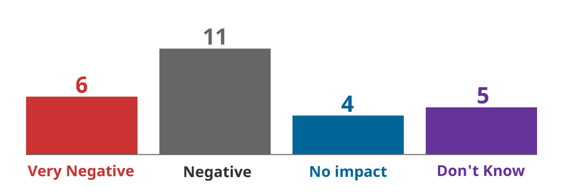
LONG DESCRIPTION: Figure 4 shows the number of responses to Question 41 on the impact of the RSSSA on the use of modern data handling, such as the Cloud:
- 6 said Very Negative
- 11 said Negative
- 4 said No Impact
- 5 said they do not know.
- Some security tools implemented to meet RSSSA goals (e.g., high-grade encryption) could be replaced by still suitable but more affordable commercial tools.
- Even for large, established companies, the burden of compliance with the RSSSA may be significant. Some procedures (e.g., creating and approving System Participant Agreements (SPAs) for new commercial partners) can take too much time and effort – to the point that business opportunities are missed.
2.2.2. Adverse Impact on some Space Businesses and Research Groups
Beyond the important “room for improvement” described by some in industry and noted above, some RSSSA stakeholders are extremely critical of the RSSSA and the resulting regulatory regime. These RSSSA stakeholders: Footnote 7
- tend to be smaller commercial start-ups or university R&D groups (an important source of innovation and opportunities for Canadian economic and social development)
- are less understanding and supportive of the policy goals of the RSSSA. Many of these stakeholders note the recent technological developments in space remote sensing that are rendering those policy goals increasingly moot (as described in Section 4 of this report).
- report the failure of research and development or loss of business opportunities due to the RSSSA
- report difficulties accessing some Canadian space data regulated by the RSSSA (Figure 5 Case Study)
Figure 5: Controls Required by RSSSA Complicate Access to Canadian Data Footnote 8
Case Study - RSSSA Complicates Use of Canadian Remote Sensing Data
- A Canadian company has developed innovative uses of space remoting sensing data to monitor and protect Canadian wetlands.
- Canada’s Radarsat Constellation Mission (RCM) would be an excellent source of data for this effort.
- However, controls on RCM data, driven by the RSSSA, make accessing RCM data more difficult than other sources.
- The Canadian innovator has accessed easily available European satellite data (Copernicus) instead of Canadian RCM data for its tool to protect Canada’s environment.
2.2.3. Impact of RSSSA on Industry is Poorly Understood
The survey results indicate that the impact of the RSSSA on industry is poorly understood, including by some in government.
This poor understanding may be the natural result of the different mandates and perspectives of the relevant stakeholders. Many of the government departments involved in the operation of the RSSSA (e.g., National Defence, GAC) have security and foreign policy mandates. The RSSSA itself does not explicitly prioritize issues such as space R&D or Canada’s economic development.
In this context, the comments of some government stakeholders make some sense:
-
“Keep RSSSA security tools “just in case” they’re needed, even if the tools are arguably not very useful.”
Some in government may also not fully appreciate how complications caused by the RSSSA can dramatically impact commercial outcomes. For example, the time and effort to create a System Participant Agreement to allow a new international remote sensing space system operator to use a northern Canadian satellite ground station may not seem excessive, but one stakeholder reported it caused enough “business friction” to cause potential international partners to pursue ground stations outside Canada to support their operations.
In summary, industry stakeholders report that when the regulator issues RSSSA licences and strikes a balance between security concerns and the interests of industry, business concerns often lose out.
3. Original Context and Purpose of the RSSSA
Approximately twenty years ago, the development of Radarsat-1 and Radarsat-2 was a key driver in the creation of the RSSSA. That series of world-leading Canadian Synthetic Aperture Radar (SAR) satellites provided considerable capability of potential military and national security value that, in the wrong hands, had real potential to harm Canadian interests. The fact that Radarsat-2 eventually became a fully commercial system not owned by government, meant that Canada could have been left without means to exercise appropriate control over sensitive national security data from that system and others like it. The RSSSA was created to address this shortfall in the government’s oversight authority.
A desire to implement certain guidelines and best practices, such as the UN Principles Relating to Remote Sensing of the Earth from Outer Space (1986) (further discussed in Section 8.2.1 below), also motivated the creation of the RSSSA.
The text of the RSSSA itself does not provide an explicit statement of the policy purpose and goals of the legislation. However, a Foreign Affairs and International Trade Canada (DFAIT) press release issued when the bill was first tabled in the House of Commons noted that the aim of the legislation was to protect "Canada's national security, national defence and foreign policy interests (emphasis added) while supporting [Canada's] continued leadership in the provision of satellite remote sensing data and services to government and private clients." Footnote 9
The heavy security focus of the Act is clearly seen in Section 8 (1) of the legislation, where the Minister may issue licences,
“… having regard to
- national security,
- the defence of Canada,
- the safety of Canadian Forces,
- Canada’s conduct of international relations,
- Canada’s international obligations and
- any prescribed factors.” Footnote 10
The primary security focus of the Act was clear. The regulatory regime created by the Act allowed for the successful licensing and oversight of Radarsat-2 and other remote sensing space systems in a manner consistent with Canada’s security and foreign policy needs.
4. Technological Development and the Current Context for the RSSSA
In the two decades that have passed since the creation of the RSSSA, dramatic progress in satellite and remote sensing technology has fundamentally changed the nature of the remote sensing space activities that the Act regulates. This section of our report introduces those technological developments and assesses their immediate impact on the relevance and operation of the Act. Section 5 deals with the impact of the Act on the conduct of space remote sensing technological development (e.g., research and development, business development) in Canada, while Section 6 considers broader and longer-term impacts of technological development on the RSSSA and Canada’s overall space governance framework.
A fundamental underlying reality drives the analysis of recent space remote sensing technological development: A large number of commercial Earth imaging satellites have been launched since the RSSSA was created, and many more will be launched in the next few years.
Figure 6 below gives some sense of this trend. By one estimate, there were almost 1,000 active Earth observation satellites on orbit as of mid-2021. Footnote 11 There are plans to launch as many as 500 such satellites every year for the next 4-5 years. Footnote 12 Over 2,160 such satellites may eventually be launched over the next decade. Footnote 13
Figure 6: Earth Observation Satellite Launches by Year Footnote 14
Text version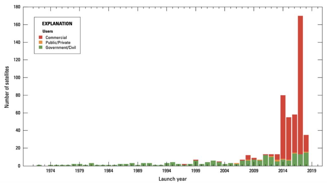
LONG DESCRIPTION: Figure 6 is a reproduction of a graph that appears in the U.S. report cited in the footnote. It shows the increase in the number of earth observation satellite launches, by type user and by year between 1971 and 2018. Until 2014, satellites launched were predominantly for government/civil use and their numbers did not go beyond 10. Thereafter, the number of satellite launches increased rapidly, with the share of commercial satellites accounting for the bulk – roughly 70 out of 80 in 2014; 45 out of 55 in 2015; 43 out of 58 in 2016; 155 out of 170 in 2017; and 23 out of 38 in 2018.
One researcher describes the coming “… Geospatial Intelligence (GEOINT) Singularity, … where real-time Earth observations with analytics are available globally to the average citizen on the ground providing a tremendous wealth of information, insight, and intelligence.” Footnote 15
The original problem the RSSSA addressed – managing security risks from a small number of unique and sophisticated Canadian remote sensing space systems – has been replaced by a new reality: large numbers of very capable imaging satellites from many countries are producing a flood of high-quality Earth observation data. As a result, using the RSSSA to control some data from the very small Canadian portion of this international flood of data provides little, if any, policy benefit for Canada.
Several technological developments have contributed to the new reality of widely-available space remote sensing information:
4.1. Large Constellations of Satellites
“Proliferated LEO” or “Mega-LEO” are catch phrases for a key technology trend: placing large constellations of small satellites in low Earth orbit (LEO). Industry is leveraging miniaturization, standardization, and advances in design and manufacturing techniques to produce low-cost, very capable small satellites. Furthermore, increased competition in the space launch industry means large constellations of these small satellites can be deployed at a reasonable cost.
Communications satellites are a prime illustration of the trend towards proliferated LEO systems. SpaceX, Amazon, Telesat, and others are pursuing constellations of hundreds and thousands of satellites to provide persistent, low-latency global communications. U.S. regulators have already agreed to license more than 10,000 such satellites. SpaceX alone has over 1,500 Starlink satellites on orbit as of mid-2021.
The trend toward proliferated LEO systems can also be seen in Earth observation satellites, i.e., the type found in the remote sensing space systems that the RSSSA regulates. Planet Labs, Satellogic, Capella, and ICEYE are just a few typical examples of companies with large and growing numbers of synthetic aperture radar (SAR) and optical Earth imagery satellites on orbit. Table 1 below provides a summary of key attributes of some of those systems. The low average revisit times are notable. As more satellites from different companies are able to revisit any point on the Earth every few hours (e.g., every 2 hours for Satellogic, every 3-6 hours for Capella), the aggregate revisit rate begins to approach something akin to “continuous” coverage for various practical purposes.
Table 1: Relevant Attributes of Key Earth Observation Constellations Footnote 16
System Type No. of satellites in orbit (mid-2021) No. of satellites planned (< 5 years) Image resolution Average revisit time (goal) Satellogic Optical 17 300+ Sub-meter (multispectral) 2 hours PlanetScope Optical 120 130+ 3-5 m 24 hours BlackSky Optical 6 60 1 m Unknown Capella SAR 7 36 Sub-meter Between 3 and 6 hours ICEYE SAR 10 Unknown 1 m (spot mode) 20 hours at equator Given this growing global collection of space remote sensing capabilities, data from any particular system is, for the most part, no longer unique or special. Space remote sensing information has instead become a commonplace commercial commodity that is widely available from many international sources. This reality drives two practical outcomes:
- Any benefit that might have come from regulatory controls on certain satellites (e.g., requiring that satellites not image sensitive areas of the Earth) is largely lost since there are so many other sources of similar information.
- Military forces and others that the RSSSA is intended to protect have already or will soon need to adapt to nearly constant surveillance from space. Therefore, the risks from space surveillance are already being mitigated in ways other than by regulation of satellites (e.g., by adjusting operational procedures of deployed forces). As a result, the regulatory controls on those satellites can be safely reduced or eliminated. For example, the recent changes in U.S. regulations (described in Section 1 below) explicitly state that U.S. regulatory controls of remote sensing space systems will be of limited duration and are intended primarily to give national security stakeholders time to adjust their operations as new global space remote sensing capabilities become widely available.
4.2. Small Satellites
Historically, typical Earth observation space systems consisted of a small number of large, highly capable satellites developed by national space organizations and major corporations. These satellites were engineered to very high reliability standards, an approach that guaranteed mission success but also drove high levels of complexity and cost.
More recently, the trend is towards smaller satellites. Definitions vary, but SmallSats are typically under 500 kg mass and can be very small, as seen in Table 2 below.
Table 2: Some Classes of SmallSats Footnote 17
Name Mass Mini satellite 100 – 180 kg Micro satellite 10 – 100 kg Nano satellite 1 – 10 kg Pico satellite 0.01 – 1 kg Femto satellite 0.001 – 0.01 kg Despite their size, SmallSats can still be very capable. The ongoing revolution in the miniaturization of electronics that has put over 11 billion transistors and incredible computing power into modern cell phones, also extends to satellites. Today’s small satellites can pack incredible computing power into a package that is small, light, and relatively low-cost.
SmallSats drive a new approach to space system reliability. When a space mission is performed by a large constellation of small satellites, the failure of any single satellite need not be mission critical. A large constellation of satellites can typically continue to perform well even if some individual satellites fail. As a result, typical SmallSats do not need to be engineered to the very-high, very-costly standards applied to large satellites – further driving down costs. SmallSats generally have shorter operational lives compared to traditional earth observation satellites, and satellites can be replaced with new models over time, maintaining the health of the constellation and incrementally improving system features and overall capability.
SmallSats – relatively inexpensive, highly capable, small, and light (and therefore more easily launched) – are a key enabler of the large constellations that are making remote sensing information a robust, commonplace, lightly-regulated global commercial commodity. This renders the security-focused regulations from the RSSSA largely irrelevant.
4.3. More and Cheaper Space Launch
The high cost of launching satellites into orbit has always been a key factor in the design and operation of space systems. Space launch was very expensive at the beginning of the space age. Those costs came down somewhat through the first decade of space operations, but remained high for subsequent decades.
In the last five to ten years, innovation in commercial launch systems has substantially reduced the cost of space launch. By one estimate, commercial launch services have reduced the cost of placing a satellite in low Earth orbit by a factor of 20 (NASA’s space shuttle: $54,500/kg; SpaceX’s Falcon 9: $2,720/kg). Footnote 18
While SpaceX has led the way in recent commercial space launch development, there are many dynamic competitors in the field that are driving the cost of space launch even lower. Virgin Orbit, Blue Origin, Rocket Lab, Astra Space, and Sierra Nevada Corporation are a few examples of the many emerging space launch options. Maritime Launch Services is a notable Canadian company building “Canada’s first commercial spaceport” in Nova Scotia.
More and cheaper space launch options are then another key enabler of the large constellations of small satellites that are transforming remote sensing space operations. With companies like Maritime Launch Services potentially entering the field, regulation of space launch is also emerging as an active issue for Canada. This issue is distinct from our review of remote sensing regulations, but adds to the impetus for an overarching analysis of Canadian space governance.
4.4. New Operational Concepts
The large constellations of small satellites enabled by various new technologies are also spurring innovation in remote sensing operational concepts. For example, the resolution of the sensors used in Earth observations satellites is a key factor determining the usefulness of those satellites for many remote sensing applications. Remote sensing space systems have typically operated at altitudes above 500 km to ensure the long operational life of large, expensive satellites. Improvements in the resolution of such systems came largely through improvements in the sensor payload.
Lowering the altitude of remote sensing satellites is another way to improve the resolution of a space system. However, there are limits to how low a satellite can successfully operate. In particular, atmospheric drag increases at lower altitudes, meaning that satellites at lower altitudes will not stay in orbit indefinitely but will suffer orbital decay and eventually completely deorbit. The lower the satellite orbit, the quicker the eventual re-entry.
Table 3 below provides a rough guide to the lifetime of an object in a circular or near circular orbit at various altitudes. The analysis assumes no propulsion is available to periodically boost the satellite orbit.
Table 3: Satellite Altitude and Natural Lifetime Footnote 19
Satellite Altitude Lifetime 200 km 1 day 300 km 1 month 400 km 1 year 500 km 10 years 700 km 100 years 900 km 1,000 years Small, inexpensive remote sensing satellites are now being operated at lower altitudes to significantly increase system resolution, while accepting a reasonable cost to replace inexpensive satellites that decay from orbit on a more frequent basis and/or include low-cost thrusters for orbit maintenance.
Such innovative operational approaches take advantage of the technology of large constellations of small satellites (e.g., inexpensive satellites, frequent launch, and replenishment of satellites). This means that regulatory oversight may need to adjust in response, for example, with frequent updates to the licences for dynamically changing remote sensing satellite constellations.
4.5. Innovation in Sensors
4.5.1. Radar Sensors
Synthetic Aperture Radar (SAR) sensors have traditionally operated in certain useful portions of the electromagnetic spectrum (e.g., the C and X radio bands). However, as competition increases for that bandwidth, manufacturers are increasingly turning to alternative frequency ranges. These include L band, which is particularly useful for measuring moisture content in soil and vegetation; Ku band, which is sensitive to water density; and Ka band, which can capture fine details. This specialization permits novel applications when imagery from multiple satellites or multiple passes of a satellite are combined, e.g., coherent change detection.
Passive Bistatic Radar (PBR) is a new technology that may require the attention of regulators. Rather than sending a radar signal, a satellite can use an existing radio signal from external sources, such as communications systems, as the beam source for a bistatic radar system. Since PBRs do not actively transmit, they can operate passively with very low power and complexity. PBR is an area of growing interest both for militaries and the commercial sector. Potential regulatory issues for PBR include the status of emitters providing the external source of radar illumination. Defining whether external illuminators are part of a regulated PBR system may be a future challenge for regulators.
4.5.2. Optical Sensors
One emerging technology for optical earth observation (EO) is the use of Micro-Opto-Electro-Mechanical Systems (MOEMS), which are miniaturized devices that can modify incoming light according to an electronic signal. For example, a MOEMS can dynamically remove overbright sources from an image, enhancing the signal-to-noise ratio of the resulting image. Beyond reducing the need for on-board computation capability, which reduces spacecraft power requirements, MOEMS have found their way into many terrestrial applications, such as metrology and medical applications. Related to the earlier-mentioned trend toward miniaturization, optical satellites are able to pack a large number of different sensors into ever smaller packages, vastly increasing the amount of relevant information captured. For example, Satellogic-ÑuSat EO, launched in 2014, incorporates multiple sensor types (pan-spectral, multispectral, hyperspectral, and thermal infrared), all while weighing approximately 37 kg.
Hyperspectral Imaging (HSI) is another important innovation. Whereas typical optical EO sensors capture between 3 to 12 frequency bands in the visible and near-infrared spectra, hyperspectral images can capture over 200, providing a “cube” of detailed frequency responses. This facilitates new and useful applications, such as detecting oil spills, soil degradation, and the health of vegetation; seeing through military camouflage; and forecasting the likelihood of volcanic eruptions and landslides. Footnote 20
Light Detection and Ranging (Lidar) is an active optical system similar to radar. However, lidar uses a laser in the visible or infrared ranges instead of the radio or microwave signal to illuminate a target. This similarity means the principles of SAR can be applied to lidar systems to produce Synthetic Aperture Lidar (SAL). This technology can potentially make images of target areas with higher fidelity and improved resolution compared to SAR. SAR and SAL systems can be used concurrently to obtain more intelligence about an area of interest compared to individual sensor types. For example, a SAR system can be used to detect ships at sea, after which a SAL system can be used to identify the type and condition of the detected ships.
4.5.3. Impact of Sensor Innovations
The ongoing innovation in the types of sensors that can be applied to remote sensing space systems means that much more detailed information and new types of information can be collected by Earth observation systems. Some of these new capabilities may give rise to new security concerns about the use of the detailed and analytically rich information that is collected. However, as with most space remote sensing data, the widespread international commercial availability of such new capabilities means regulatory controls of such systems will be of limited practical national security value and would impede the best use of new sensor innovations for the benefit of all.
4.6. Processing and Exploitation
Even as the capabilities of EO satellites grow with new technologies, the ability of users to process and interpret the data these technologies provide grows alongside them. These analytical systems are driven and enabled by current technology trends, such as parallel computing, cloud computing, big data analytics, artificial intelligence, inter-satellite communications, continuous and global EO, and ubiquitous networks for guidance and navigation purposes.
EO data is becoming increasingly more accessible thanks to efforts by governments and private companies to treat access to this data as a public good. The free and open data benefits the public by assisting with navigation, agriculture, news reporting, and emergency response, among many other applications. For these reasons, many current government-owned and operated satellite missions provide EO data without restrictions, either for free or at a marginal cost. The trend in unrestricted data is expected to continue due to an increasing number of civilian EO missions and an increased emphasis on international cooperation over the last couple of decades. The data controls imposed on systems licensed under the RSSSA run counter to the international trends toward more open data and complicate Canadian efforts to contribute data to the public good.
While the EO data is expected to remain open, the extraction and exploitation of information from data is rapidly becoming a lucrative field that many small companies are starting to pursue. The application of deep learning and other big data techniques allows these companies to sift through large volumes of publicly available data to extract meaningful information, insights, and analytics.
Traditionally, image analysis has been done by human operators examining and analyzing incoming optical and SAR data, which requires a significant amount of training, resources, and time. Advances in artificial intelligence, machine learning, big data analytics, and cloud processing allow analysts to process much larger sets of data at a much faster rate. This includes pre-processing on the satellite itself and post-processing at the ground station or by the end user.
4.7. Quantum Technology
Quantum sensors and communications form a broad class of instruments and technologies whose performance is not limited by the boundaries of classical physics. Currently, at a very low Technology Readiness Level (TRL) Footnote 21 , quantum technology nevertheless holds promise in 10 to 20 years for many practical applications, including for remote sensing space systems, such as:
- quantum communications with unparalleled security, high data rates, and improved efficiency
- Quantum Key Distribution (QKD) for improved cryptographic security
- quantum radar for improved accuracy and SAR image quality
Application of quantum technology to remote sensing space systems is a long-term possibility that may require future attention by regulators and subsequent Independent Reviews of the RSSSA.
4.8. Blockchain
Blockchain is a specific type of data structure using distributed ledgers Footnote 22 to store and transmit data in packages called “blocks,” connected in a digital “chain.” Blockchains employ cryptographic and algorithmic methods to record and synchronize data across a network in an immutable manner.
Blockchain technology has the potential to transform global data markets, including Earth observation data, with decentralization, immutability, security, and transparency. Blockchains may not be immediately applicable to space systems and the exploitation of Earth observation data. However, this perspective may change rapidly as the technology improves and new examples of the added value of blockchain are progressively revealed.
Regulatory approaches to the security of remote sensing space data may need to change to take advantage of the security opportunities provided by Blockchain technology and facilitate innovation in the design and operation of remote sensing space systems.
4.9. Anticipated Future Advancements in Earth Observation Technologies
Ongoing changes in Earth observation technology are having a significant impact on how the RSSSA should be implemented in the near term and possibly amended in the future. For additional context and background information in understanding these trends:
- Annex B provides a summary of anticipated technology developments that will impact Earth observation systems in the next five and twenty years. The listing includes Technology Readiness Levels (TRL 1 to 9) that give a sense of the maturity of each technology.
- Annex C provides list of publicly-known existing and near-term Earth observation systems.
5. Impact of the RSSSA on Technological Development
The RSSSA calls for the periodic independent reviews of the Act to assess, among other things, the impact of the Act on “technological development”.
Our 2022 Independent Review of the RSSSA recognizes the recent rapid and accelerating advance of satellite and remote sensing technologies and the need for “a more thorough examination of the impact of the Act on technological development”, in accordance with the Statement of Work for the conduct of the Independent Review.
“Impact … on technological development” is a broad concept. We see three primary areas of technological development impacted by the RSSSA:
- Research and development conducted by universities, industry, and others is a key source of new technological development that faces roadblocks from the RSSSA.
- Space remote sensing businesses are the “rubber hitting the road” of technological development, creating remote sensing space systems and using the data from those systems to deliver solutions to problems here on Earth. These businesses must be licensed under the RSSSA and, therefore, face incremental cost and complexity in their operations due to the provisions of the Act.
- The widespread analysis and exploitation of space remote sensing information, often leading to new and unexpected applications of that knowledge to a range of human endeavours, is another critical area of innovative technological development that is affected by the RSSSA.
5.1. Impact of the RSSSA on Research and Development
Canadian universities are an important source of R&D for remote sensing space systems, including work on the technology of the satellites themselves (e.g., SmallSat engineering, sensor development) and on the exploitation of the data they produce.
Test flying actual satellites in orbit can be an important element of a space R&D program. The ongoing revolution in small, inexpensive satellites and cheap space launch has allowed smaller R&D groups, including Canadian universities, the opportunity to fly their own R&D satellites. In turn, the benefits of such research flow back into improvements in space technology, creating a virtuous cycle of technological development. There are a variety of avenues to pursue such work in Canada, sometimes with government support, including various Canadian Space Agency programs like Flights and Fieldwork for the Advancement of Science and Technology (FAST), smartEarth, the Space Technology Development Program (STDP), and the Canadian CubeSat Project (CCP).
However, complications arise when it comes time to actually put an R&D SmallSat into Earth orbit. If an R&D satellite does any form of remote sensing – i.e., “… is capable of sensing the surface of the Earth through the use of electromagnetic waves”, in the broad language of the RSSSA – then a licence under the Act is likely required. The scientists, engineers, and students of a university R&D group must then deal with the requirements for RSSSA licensing (e.g., system documentation, program management reports, government security vetting of personnel).
Various stakeholders reported to the Review Team that the time, cost, and complexity of an RSSSA licensing process for their R&D satellite was a significant drag on their R&D programs. This lost time and effort were problematic even if their engagement with GAC – trying to understand the broad definitions and practical applicability of the Act – led to an eventual conclusion that a licence was not required.
R&D on new techniques to use space remote sensing data are also impacted by the RSSSA. For instance, the handling of certain types of remote sensing data (e.g., Raw data, Single Look Complex) is restricted under the Act. The resulting requirements, such as System Participant Agreements and security vetting, to access such information, however, limit what organizations and people can contribute to Canadian R&D programs and hinder innovation using that data.
Canadian industry faces many of the same challenges as academic space remote sensing R&D programs. Larger companies may have more experience and resources to deal with regulatory authorities and address the requirements of the RSSSA, but the incremental cost, complications, and limitations driven by the Act are still problematic for industry R&D programs.
5.2. Impact of the RSSSA on Space Remote Sensing Businesses
Commercial remote sensing technology development is extremely dynamic and competitive on a global scale. Canadian companies must be agile and innovative to successfully respond to the rapid changes in the global market, both from the perspective of user needs and the technology development to satisfy those needs.
Drawing in large measure on our stakeholder engagement for this Independent Review (further elaborated in Section 2), we see several areas where the RSSSA affects the agility and innovation of the Canadian remote sensing space industry:
- The continued focus of the RSSSA on managing risks to Canadian security and foreign policy interests while other jurisdictions (e.g., the United States) now specifically prioritize support of their national remote sensing industry in their equivalent regulations, puts Canadian industry at international competitive disadvantage.
- Uncertainty in the language of the Act – for example, in the definition of “remote sensing” and the prevalence of Radar-specific terminology when other types of systems (e.g., optical) are also being regulated – creates uncertainty for businesses about if and how the Act will be applied to their systems. Such uncertainty complicates business planning and limits opportunities to raise capital, among others.
- Important new technologies (e.g., non-Earth Imaging, Radio Frequency sensing, cloud computing, and cloud storage) can be difficult to implement under the RSSSA.
- The burden of compliance with the RSSSA is significant. Some procedures required under the Act (e.g., controlling raw data, creating and approving System Participant Agreements for new commercial partners) can be resource intensive and take more time and effort than an agile entity can afford.
Some industry stakeholders told the Independent Review that they had lost business opportunities because of the RSSSA.
Other reviews and studies have noted similar concerns, including the Space Advisory Board Round Table on Canada’s Future in Space, which identified significant concerns about the RSSSA restricting innovation and growth in Canada, including in the North. Footnote 23
5.3. Impact of the RSSSA on Innovation in the Use of Remote Sensing Space Data
The ultimate purpose of creating remote sensing space systems is to obtain data that can be used to solve problems on Earth. Large quantities of increasingly diverse types of Earth observation data are now being produced by remote sensing space systems. Making that data widely available to customers around the world is key to achieving the ultimate goals of technology development, such as:
- creation of new, innovative, sometimes unexpected applications of data from space systems
- combination of space remote sensing data with other sources of “Big Data” (as discussed in Section 3 below) to solve previously intractable problems
- progress towards democratized Earth observation data – when everyone has access to the same accurate, timely information – to raise the level of public discourse and decision-making (as discussed in Section 4 below)
Unfortunately, the security focus of the RSSSA drives the systems it regulates away from open access to the data produced. For example, only 3% of data from the Government’s Radarsat Constellation Mission (RCM) is free and open to the public. Despite being unclassified, another 50% is only available to Canadian businesses and universities (but not individuals) that pass a security screening process known as “vetting”. Footnote 24
The restrictions that the RSSSA places on open access to the data produced by systems licensed under the Act is an important impediment to space remote sensing technological development in Canada.
6. Further Implications of Technology Development for the RSSSA
The technology development introduced in Section 4 above may have additional implications for the RSSSA and other Canadian regulatory frameworks.
6.1. Data Controls
The language of the RSSSA focuses on the control of one specific type of data: Raw data from SAR systems. Other types of data (e.g., optical, thermal, hyperspectral) are not specifically mentioned. This anomaly in the RSSSA is no doubt due to the initial focus of the creators of the Act on the need to regulate Radarsat-2. However, the focus in the RSSSA on SAR raw data and not on data from other types of sensors creates two important issues:
- SAR data is a complex, rich source of information that can be exploited using a variety of analytical techniques, some well-established and others that continue to emerge from new R&D efforts, e.g., Interferometric Synthetic Aperture Radar (InSAR), polarimetric synthetic-aperture radar interferometry (PolInSAR). However, R&D and commercial implementation of such cutting-edge SAR technology is hampered by the specific restrictions on the distribution of radar data imposed in some RSSSA licences.
- The fact that the Act uses specific language focused on certain types of raw radar data, but no such language about other types of data creates uncertainty about the regulatory status of the other types of data. For example, does the language of the Act imply there are fewer regulatory concerns about non-radar data? Any update to the Act or Regulations should clarify these issues, paying close attention to new and emerging sensor types and the data they produce.
As discussed in Section 2.2.1 above, stakeholders report another RSSSA data control issue with the use of cloud technology as part of a system licenced under the Act. This is not a technology issue as such. Instead, government security policy on the use of cloud computing has been unclear. Industry may, therefore, avoid the uncertainty and any potential problems with their RSSSA licence application by choosing more costly, less optimum data handling solutions.
6.2. Privacy
Space remote sensing has brought us tremendous knowledge and insights about our planet and human activities. This knowledge was initially available only to governments and national security entities but is now available to commercial clients around the world. The primary regulatory response to these systems has been to manage any potential national security risks as access to this valuable knowledge spreads from governments to wider audiences. The RSSSA is an example of this regulatory approach.
Now that space remote sensing information has become a commonplace commercial commodity, there is little need to continue the national security-focused regulation of such systems.
However, concerns about privacy might drive a new and different regulatory imperative for space remote sensing. The ever-increasing numbers of remote sensing satellites in Earth orbit are approaching a point of ubiquitous coverage of the planet and have the potential to infringe on the privacy of organizations and individuals.
While the RSSSA was designed in large part to protect national security interests from space surveillance, new regulations may soon be needed to protect the privacy of Canadian society in the face of such surveillance.
6.3. Big Data
Big data, machine learning, and artificial intelligence are technologies, like space remote sensing, that require careful consideration of potential regulatory responses to address societal concerns.
Big data techniques are bringing great benefits to society but assembling huge sets of data and applying sometime opaque algorithms to extract new insights can have unintended negative consequences. Regulatory oversight may be called for to protect the greater good.
There is an important overlap between the worlds of big data and space remote sensing. Big data generally works better on the largest possible dataset. Space systems collect vast amounts of data and are emerging as a key source of grist for the big data mill. However, adding satellite data to other big data sources is a double-edged sword. While remote sensing data can enhance the safety and security of individuals and their communities, it can also severely infringe on their privacy.
The two sets of closely related, rapidly growing, and dynamic technologies – big data and space remote sensing – raise questions across several regulatory domains (e.g., remote sensing, individual privacy) that government could best address in a coordinated fashion.
6.4. Technology Summary
Technological developments have transformed the nature of space remote sensing of the Earth in the fifteen years the RSSSA has been in force. The explosion in the numbers and quality of global commercial space remote sensing capabilities means controlling a small number of Canadian remote sensing space systems for national security purposes under the RSSSA now provides very limited practical policy benefits.
However, technology trends in the production and use of Earth observation data are raising new issues with regulatory implications that government should consider for any future evolution of the RSSSA and the other related regulatory regimes:
- Data – whether collected from air, space, or any other means – has been integrated into all aspects of everyday life. Any interruptions to the availability of data can be catastrophic. Regulations may be needed to safeguard Canadians against data interruptions.
- Giving every stakeholder access to the same accurate, timely information – democratized EO data – can raise the level of public discourse and help communities make better-informed decisions. Regulations should facilitate democratized data.
- With the proliferation of EO sensors, companies are striving to be the first to implement a fully functional, near-constant monitoring of the Earth at a very fine resolution. Regulations may be needed to protect the privacy of Canadians in the face of this ubiquitous surveillance from space.
Space remote sensing technological developments will continue at a rapid pace. The Canadian remote space sensing regulatory framework should include assessments of the impact of technological development on the Act more often than the five-year review timeline.
7. The RSSSA within Canada’s Patchwork of Space Governance
The RSSSA operates alongside several other pieces of federal legislation and policies that touch on space issues. In some cases, space is a small part of a larger government policy mandate (e.g., regional economic development, radio frequency spectrum management). In other cases, like the RSSSA, legislation has been created to deal with specific space activities. However, Canada has no overarching space legislation to comprehensively manage and coordinate the complete space portfolio. For the most part, Canada’s various space-related laws and policies function independently of one another.
Within this loose patchwork of Canadian space governance, the RSSSA plays a significant role. It is one of the very few space-specific federal Acts and the regulatory framework it creates for an important subset of Canadian space activity – remote sensing from space – is very robust. The RSSSA is the keystone of the Government of Canada’s oversight of an important element of Canadian space activities (Canadian Earth observation revenues totalled $278M in 2018) Footnote 25 , but for a purpose that is less and less useful as time passes: the RSSSA was created to address security concerns and is not designed to balance and implement all of Canada’s policy objectives for space, including the use of space systems for the benefit of all Canadians. Non-security-related policy objectives are not well served by the role of the RSSSA in governing remote sensing space systems.
7.1. The Evolution of Canadian Space Governance
Over the decades, Canada has addressed the oversight and regulation of emerging space activities through incremental changes to pre-existing legislation that overlapped with new space activities (e.g., airspace regulation by Transport Canada, radio frequency spectrum regulation by ISED), and with two pieces of space-specific legislation: the RSSSA and the Canadian Space Agency Act (Figure 7).
Figure 7: Canadian Space-Related Legislation
Canadian Space Governance is a Patchwork
- Transport Canada regulates Canada’s airspace, including space launch, under the Canadian Aeronautics Act (1985).
- ISED regulates radio frequency spectrum for all uses, including for satellites in space, under the Radiocommunication Act (1985).
- CSA supports space R&D under the Canadian Space Agency Act (1990).
- Global Affairs Canada regulates remote sensing space systems under the Remote Sensing Space Systems Act (2005).
Various departments and agencies have also developed other space-related policies and strategies that largely focus on individual departmental needs and priorities. These include:
- The Canadian Space Agency (CSA)
- Long Term Space Plans (1986, 1994, 2003, 2008)
- Space Policy Framework (2014)
- New Space Strategy for Canada (2019)
- Strong, Secure, Engaged (2017): Overall defence policy with some space content
7.2. RSSSA Plays a Unique Role in Canadian Space Governance
Within the patchwork of Canadian space laws, policies, and strategies described above, it can be difficult for all the relevant government officials to collectively and comprehensively balance all the government priorities and opportunities that may involve space in one way or another. This is especially important when such priorities and opportunities may compete with one another. For example:
- Because of the nature of preferred orbits for certain types of satellites, northern Canada is an ideal location for remote sensing satellite ground stations. Building and operating satellite ground stations represents a significant economic and social development opportunity for northern and First Nation communities. However, there are also potential security and foreign policy concerns in the operation of such ground stations, for example ensuring that data moving through Canadian ground stations is not used for any illegal purpose.
- Many Canadian companies and universities conduct research and development into new space technologies that can be drivers for Canada’s science and innovation agendas. However, remote sensing R&D satellites are subject to the RSSSA. When the Act is applied, the resulting security constraints can add cost and complexity to those systems and be a significant and costly burden on space R&D programs.
How then are competing government goals that may impact a given space initiative reconciled? For example, how is the decision made whether economic opportunities, such as expanding or building new satellite ground stations, justify assuming some level of national security risk associated with a new remote sensing space system (Figure 8)?
Figure 8: RSSSA Limits Use of Canadian Ground Stations Footnote 26
RSSSA and problems for Canadian Ground Stations
- Due to its geography, Canada has a major opportunity to supply northern ground stations to support polar orbiting satellites and grow northern economies.
- However, the RSSSA creates obstacles to realizing this opportunity, e.g., in Inuvik:
Text version
LONG DESCRIPTION: Figure 8 includes text extracted from SPACENEWS news clip, only available in English. See Planet ground station caught in Canadian regulatory limbo - SpaceNews.
- Other stakeholders also report difficulty using Canadian ground stations due to the RSSSA:
- A Canadian ground station operator reports that licensing downlink of a new data type (radio occultation) under the RSSSA was unduly complicated. A potential international customer went elsewhere.
- A Canadian remote sensing company finds it hard to downlink foreign data in Canada because of complications under the RSSSA, such as the requirement for System Participant Agreements (SPAs).
- A major international aerospace company finds that even a “short” 6-to 12-month process to create SPAs under the RSSSA for new customers is unworkable: potential customers may go to other companies elsewhere in the world.
In the absence of overarching Canadian space legislation or policy, the RSSSA provides the decision-making framework that must balance any competing priorities (e.g., national security, economic development) that come into play when licensing remote sensing space systems. In effect, the RSSSA licensing process is the interdepartmental governance mechanism for those systems. This can be problematic because the RSSSA was primarily designed to address security and foreign policy concerns and not other important government goals and priorities, such as economic development.
7.3. Exempting the Crown from the RSSSA
Some stakeholders argue that the RSSSA should not be applied to government remote sensing space systems, for example those systems operated by CSA or DND. Lending some credence to this position, Section 4 (2) of the Act gives the Governor in Council broad authority to limit how the Act is applied to remote sensing space systems operated by CSA and DND.
One of the major conclusions of this Independent Review is that the controls imposed on remote sensing space systems under the RSSSA can be significantly reduced without compromising Canadian security and foreign policy interests. Any such reductions in the application of the RSSSA would certainly apply to systems operated by the Government. The fact of government ownership of such systems should be an important factor in any licensing risk-benefit analysis that might well conclude, on a case-by-case basis, that no licence was required for a given government-operated system.
However, the RSSSA has created an effective de facto process for interdepartmental coordination on important national security, economic security, and foreign policy issues associated with Canadian remote sensing satellites, including government satellites. The value of such a formal, disciplined interdepartmental coordination process dealing with these issues should not be underestimated. That value would be lost if government operators were given blanket exemptions from the RSSSA for all their remote sensing space systems. We do not recommend any blanket exemptions to the RSSSA for the Crown.
7.4. Impact of the RSSSA within Canada’s Space Governance Patchwork
The RSSSA has a unique place in Canadian space governance, as a formal regulatory framework overseeing an important portion of Canada’s activity in space (i.e., remote sensing). From this unique place, the security and foreign policy priorities of the Act, driven in large measure by twenty-year old technical and political circumstances, have significant and unwelcome implications for today’s efforts to develop and exploit space systems for the benefit of all Canadians.
7.4.1. Security Issues Dominate Decision-making
As noted in Section 3 above, the RSSSA requires that the Minister consider five specific Canadian security and foreign policy concerns before issuing a licence under the Act. The subordinate Remote Sensing Space Systems Regulations that implement the Act include an additional provision to consider “the enhancement of the competitiveness … of the Canadian remote sensing space industry” in the licensing process.
In practice, government officials tend to be quite cautious about assuming any security risks when issuing a licence under the Act. Instead, they take a precautionary approach and, as much as possible, seek to eliminate or mitigate any security risk, for example:
- The “safety of Canadian Forces” is protected in part via detailed controls, imposed in each licence, on areas of the Earth that a remote sensing space system is allowed to image and what customers are allowed to receive in terms of data.
- Concerns about the security configuration of a ground station may result in significant delays in the licensing process or in requirements to change a system design.
It is certainly appropriate for key government departments to raise their specific concerns in the RSSSA licence review process. For example, DND must highlight any concerns it may have about the potential effect of proposed space systems on the safety of Canadian Forces.
When security concerns dominate the licencing process, however, other important issues and priorities can be left behind, such as:
- securing economic opportunities for Canada (e.g., supporting the creation and use of Canadian northern satellite ground stations by minimizing licensing hurdles for foreign clients)
- minimizing or eliminating incremental costs to industry (e.g., costs for additional system components to meet security requirements, incremental documentation, and reporting costs)
7.4.2. Unintended Barriers to Entry for R&D and Business
Given the focus of the RSSSA on managing potential security risks associated with remote sensing space systems, it is natural that many of the provisions in a licence issued under the Act contain security requirements, for example:
- Some company officials may require some level of personal security vetting.
- Data handling systems must meet specified security requirements.
- Satellite telemetry, tracking, and control communication links must be carefully protected (e.g., using encryption).
Each of these individual requirements may not seem to be particularly onerous for a licence holder to meet. However:
- The sum total of such requirements can represent a significant time and cost burden for some potential satellite projects, especially in small organizations or start-ups.
- Some potential licence holders (e.g., university R&D groups) may have limited understanding and resources to engage the government security bureaucracy, as in the case for personnel security vetting, for example.
- Once a system is licensed and in service, the security controls can make it difficult for many potential beneficiaries of the system to gain access to the data. For example, some Canadian university researchers told the Review team they avoid using Radarsat data because the process to access that data is more trouble than it is worth. Anecdotal comments have extended that example: If university professors find it too hard to access RSSSA regulated data, imagine the difficulty faced by small, disadvantaged communities (e.g., small municipalities, northern communities, First Nations) to access space data that could otherwise enable innovation and transformative change for those communities (e.g., environmental monitoring and enforcement, wildlife protection, and many more existing and yet to be invented applications).
However unintended, the RSSSA represents a significant barrier to entry for some new Canadian space remote sensing businesses and R&D programs. Canadians and others may not be able to take full advantage of data from Canadian remote sensing space systems, even taxpayer-funded systems like Radarsat Constellation Mission.
7.4.3. RSSSA Versus Initiatives for Open Government
The licence review process under the RSSSA includes an interdepartmental assessment of the potential risks to Canada’s security from proposed remote sensing space systems and the identification of control measures to be imposed under the Act to mitigate any such risks. The risk and data management approaches that emerge from this process are, in effect, “closed by default”. There is a positive requirement to clear security hurdles before systems can be licensed and data can be provided to customers. Also of note, the review process is not public – with some justification – given its security focus.
This security-focused, “closed by default” nature of the RSSSA is consistent with the original policy goals of the Act from twenty years ago, but runs contrary to more recent federal initiatives that are designed to promote open government, such as:
- The 2014 Treasury Board “Directive on Open Government” Footnote 27
- The 2020 “Roadmap for Open Science” Footnote 28
- The “Open Data Principle” Footnote 29
The “closed by default” approach of the RSSSA was appropriate for the original circumstances and purpose of the Act. However, changes in those circumstances – described in Section 4 of this report – suggest that “closed by default” may no longer be required. Not all data can be open, but the new circumstances surrounding the RSSSA and described in this report represent an opportunity to bring the administration of the Act more into line with open government goals.
8. Canada’s International Obligations and the RSSSA
As noted above in Section 7, Canada’s space regulatory framework is fragmented and incomplete. Within this disjointed framework, the RSSSA – one of the only pieces of legislation directly governing a specific Canadian space activity – plays an important, albeit partial, role in allowing Canada to meet its international space obligations. We examine Canada’s international space obligations, the role of the RSSSA in meeting those obligations, and where Canada can improve how it meets such obligations.
For this review, we define “international obligations” as legally-binding obligations arising out of treaties, international agreements, customary international law, or unilateral declarations made by a representative of the government of Canada. The relevant international space obligations arise from the treaties and agreements listed in section 8.1 below. These obligations tend to be loosely defined and easily met.
Our analysis also considers so-called soft law obligations, those norms or principles that are not legally binding but provide best practices or have persuasive practical, social, or political value. These may come from Guidelines or Resolutions adopted by organizations such as the UN General Assembly (GA) or the UN Committee on the Peaceful Uses of Outer Space (COPUOS), or from best practices expressed by recognized non-governmental organizations. While these are not legally-binding obligations, we consider them in our assessment of the degree to which Canada is meeting its overall international space obligations. We also consider Canada’s statements concerning these norms and the voting pattern by Canada on the adoption of such non-binding international instruments.
8.1. Binding International Space Obligations
For Canada, there are two sources of binding international space obligations applicable to remote sensing space systems:
- relevant UN treaties and conventions that Canada has subscribed to, and
- Canada’s June 2000 bilateral agreement with the United States concerning commercial remote sensing satellites
8.1.1. UN Treaties and Conventions
Among the broad range of space-related treaties, conventions, and other agreements that Canada has signed and ratified, three key United Nations (UN) treaties and conventions give rise to specific international obligations applicable to remote sensing space systems: the 1967 Outer Space Treaty, the 1971 Liability Convention, and the 1976 Registration Convention.
Canada is also a member of the International Telecommunications Union (ITU) and a signatory to the ITU Constitution and Convention and obliged to adhere to the regularly updated Administrative Regulations. Therefore, Canada is responsible for ensuring no licenced activities cause intentional “harmful interference” to the radio frequencies used by other duly-registered actors in exercise of their space activities. However, ITU-related responsibilities are administered in Canada by ISED under the Radiocommunication Act and are not considered further in this review of the RSSSA.
8.1.1.1. The Outer Space Treaty (1967)
The 1967 Outer Space Treaty (OST) provides the basic legal framework for all space activities. In particular, Article VI provides that states are responsible for national space activities, whether carried out by governmental or non-governmental entities. States must “authorize and continually supervise” all space activities taking place under their jurisdiction.
For Canada, Sections 5 and 6 of the RSSSA require the authority of a licence for the operation of remote sensing space systems by Canadian operators worldwide and foreign operators in Canada. The resulting RSSSA licensing regime allows Canada to ensure that the remote sensing space systems it licenses meet Canada’s international obligations. As such, Canada is compliant with Article VI of the OST, at least for that subset of Canadian space systems that are subject to the RSSSA.
8.1.1.2. The Liability Convention (1971)
The 1971 Convention on International Liability for Damage Caused by Space Objects elaborates on Articles VI and VII of the OST. The Convention defines a “launching state” as a state that launches or procures a space object’s launch, or from whose territory an object is launched. Launching states are absolutely liable for damages caused on Earth or in the airspace of another state, and liable where there is a fault for damage caused in any area beyond national jurisdiction, including in space.
As stated in the 2012 Independent Review of the RSSSA, given the liability the Government of Canada has assumed as a signatory to the 1971 Convention, it might be prudent for Canada to obligate Canadian space operators to carry relevant liability insurance. Many states require insurance for activities under their jurisdiction as a licence condition. Legislation such as the RSSSA could be a vehicle to implement this requirement, but there are no such provisions within the current Act or its Regulations.
In any event, Canada’s commitment to its international obligations under the Liability Convention has not been tested in practice. Given that Canada is the only state to have officially triggered the Liability Convention, in response to damage to Canadian territory by a Soviet-owned space object, Footnote 30 we expect Canada would meet such obligations, albeit at some apparent risk to the Canadian taxpayer (e.g., paying for damage caused by Canadian commercial space operators).
8.1.1.3. The Registration Convention (1974)
The 1974 Convention on Registration of Objects Launched into Outer Space creates a mechanism to identify and track space objects, namely the United Nations Register of Objects Launched into Outer Space. The Convention requires that states create national registries of all space objects launched under their jurisdiction and provide specific technical information to the UN Office of Outer Space Affairs, which maintains the UN Register.
In Canada, the responsibility for national and UN registration of satellites lies with the Canadian Space Agency. The RSSSA does not provide specific requirements for registration of satellites but, in the practical operation of the RSSSA licensing regime, applicants are notified of the requirement to deal with CSA for registration of satellites. The RSSSA licensing process collects considerable detailed information about the satellite systems. That information can support the registration process and could also facilitate meeting global calls for greater transparency and sharing of information in support of international space situational awareness, space traffic management, and other similar initiatives.
Canada meets its international obligations for registration of satellites, with the RSSSA licensing regime providing support for the registration of that subset of Canadian satellites that are remote sensing satellites.
8.1.2. Canada-U.S. Agreement Concerning Commercial Remote Sensing Satellite Systems (2000)
The creation of the RSSSA was a response to concerns beginning in the 1990s that new commercial remote sensing satellites could provide unique high-value information that required some government regulation to ensure it was not used in ways that might harm Canada’s interests. In particular, the emergence of Radarsat-2 as a highly capable and purely commercial follow-on to Radarsat-1 drove urgent consideration of the need for a Canadian space remote sensing regulatory regime. The RSSSA was also in part a response to related American concerns about Canadian space systems with some U.S. technology content or other U.S. involvement (e.g., potential use of U.S. launch services).
The Agreement Between the Government of Canada and the Government of the United States of America Concerning the Operation of Commercial Remote Sensing Satellite Systems was put in place in June 2000 to address immediate concerns about Radarsat-2, while new Canadian legislation (the RSSSA) was developed and eventually brought into force in 2007.
The bilateral agreement calls on Canada and the United States to “ensure that such commercial remote sensing satellite systems will be controlled by each Party in a comparable manner…” Footnote 31
The operational elements of the agreement only apply to specific systems as agreed by the parties, which only includes Radarsat-2, according to the available public information. By all accounts, Canada and the US are satisfied with the functioning of the bilateral agreement and the subsequent role of the RSSSA.
However, it is worth noting that the United States extensively revised its space remote sensing regulations in 2020, having recognized that its regulation of U.S. companies was largely ineffective – due to the availability of similar data from international competitors – and only served to disadvantage U.S. companies. Under the previous U.S. regulations, international EO companies were able to offer data at higher resolutions than U.S. companies were allowed to provide, placing U.S. companies at a distinct competitive disadvantage.
The US has, therefore, made a philosophical shift from evaluating remote sensing applications from a national security risk perspective towards supporting U.S. industry. The U.S. government will focus on ensuring U.S. commercial remote sensing remains competitive in the global remote sensing market and mitigating the national security risks of commercial space remote sensing systems primarily by non-regulatory means. In implementing this new approach, “[the Department of] Commerce will categorize systems based on an analysis of whether the unenhanced data to be generated by the proposed system are already available in the United States or other nations.” Footnote 32
These recent fundamental changes to the U.S. philosophy for regulating commercial space remote sensing systems have created a stark difference between the applicable Canadian and American regulatory regimes. The US has recognized and responded to the changing realities in the global space remote sensing market, while Canada continues to focus primarily on the security risks associated with remote sensing space systems. The bilateral agreement can be a driver for Canada to adopt less restrictive, industry-promoting remote sensing regulations.
The bilateral agreement may have outlived some of its usefulness given the subsequent creation of the RSSSA, which embodies the regulatory goals of the bilateral agreement. However, the bilateral agreement remains binding and its general provisions do facilitate continued coordination and collaboration by Canadian and U.S. regulators. Such collaboration can be an important tool in a process to reform and update Canadian remote sensing space system regulations.
8.2. “Soft” (non-binding) International Space Law
Aside from the binding international legal framework, there are some important non-binding instruments that have developed through international space diplomacy in the years since the RSSSA came into force. Such instruments and mechanisms are referred to here, as in much literature, as “soft law” to reflect the fact that while they have no legal force, they are important instruments designed to create some international uniformity of standards and practices, and to stimulate domestic legislation. Here we consider some UN sources of soft-law international space obligations for Canada:
- UN General Assembly Resolution 41/65 on Principles Relating to Remote Sensing of the Earth from Outer Space
- The Inter-Agency Space Debris Coordination Committee (IADC) Debris Mitigation Guidelines
- The UN Guidelines for the Long-term Sustainability of Outer Space Activities
- UN General Assembly Resolution 75/36 Reducing space threats through norms, rules and principles of responsible behaviours
- The Charter on Cooperation to Achieve the Coordinated Use of Space Facilities in the Event of Natural or Technological Disasters (Disaster Charter)
8.2.1. Principles Relating to Remote Sensing of the Earth from Outer Space (1986)
UN General Assembly Resolution 41/65 is a longstanding statement of principles created at the tail end of the period of successful cooperation on international space governance that marked the first years of the Space Age (e.g. from the Outer Space Treaty (1967) to the Moon Agreement (1979)). The UN Principles are intended to promote remote sensing “… for the benefit and in the interests of all countries …”
Of note, Principle XII calls for sensed states to have access to remote sensing data concerning territory under their jurisdiction. Canada responds to this principle in the Remote Sensing Space Systems Regulations, Schedule 1, Section 7, which requires applicants for a licence to describe:
- “7. The applicant’s plans for communicating raw data or providing remote sensing products, including
- (a) making the data or products available to governments whose territories have been sensed by the remote sensing space system”; and …
These UN Principles also provide accepted international definitions of key terms such as:
- Remote sensing: “means the sensing of the Earth’s surface from space by making use of the properties of electromagnetic waves emitted, reflected or diffracted by the sensed objects, to improve natural resources management, land use and the protection of the environment …”
- Remote sensing activities: “means the operation of remote sensing space systems, primary data collection and storage stations, and activities in processing, interpreting and disseminating the processed data.” Footnote 33
The RSSSA does not use the definitions from the UN General Assembly 41/65 Principles. Instead, it defines “remote sensing satellite”, “raw data”, and “remote sensing product” and does not refer to or define “remote sensing”, “primary data”, “processed data”, and “analyzed information” that are defined in the UN document. Footnote 34
If Canada amends or replaces the RSSSA, there may be benefit in reflecting on these UN definitions.
However, as remote sensing technology has diversified and become more sophisticated, it would not be necessary to adhere strictly to the terms in these UN Principles.
8.2.2. IADC Debris Mitigation Guidelines (2007)
Canada is a member of the Inter-Agency Space Debris Coordination Committee (IADC), exchanging information on space debris research and activities.
In 2007, the IADC adopted the Space Debris Mitigation Guidelines, which the UN COPUOS subsequently also adopted. The Guidelines include recommendations to mitigate and control satellite debris during the development and operation of space systems. Footnote 35
Typical Canadian remote sensing regulatory practice applies the IADC Space Debris Mitigation Guidelines to a significant degree. Licensees are required to assess and mitigate debris risk for the life of proposed satellites, including end-of-life operations.
8.2.3. UN Long Term Sustainability Guidelines (2019)
The UN Guidelines for the Long-Term Sustainability of Outer Space Activities (LTS Guidelines) are the recent product of a challenging, decade-long program of work by the Committee on the Peaceful Uses of Outer Space. Footnote 36 The 21 voluntary guidelines are intended to ensure the long-term sustainability of outer space activities and enhance the safety of space operations.
To some degree, the 2019 LTS Guidelines are a recent codification of best practices that have been well understood by many states for some time. So it is not a coincidence that the 2007 RSSSA embodies many of these best practices, even though it pre-dates the LTS Guidelines. These elements of the RSSSA include:
- providing, in part, a national regulatory framework for outer space activities (LTS Guideline A.1)
- creating a licensing process that supervises some national space activities (LTS Guideline A.3)
- requiring that applicants for a licence provide a satellite disposal plan, thus encouraging debris mitigation (LTS Guideline B.8)
The RSSSA is, therefore, a useful basis for Canadian efforts to implement the LTS Guidelines.
However, given that the RSSSA only applies to remote sensing activities, it can be only one piece of a broader Canadian effort to successfully implement the LTS Guidelines. New, comprehensive Canadian space legislation could play a key role in implementing the Guidelines into binding law and demonstrating Canadian leadership on these important internationally-applied best practices.
8.2.4. UN General Assembly Resolution 75/36 on Reducing space threats through norms, rules and principles of responsible behaviours (2020)
Through Resolution 75/36, the UN General Assembly encouraged Member States to: study existing and potential threats and security risks to space systems, including those arising from actions, activities, or systems in outer space or on Earth; characterize actions and activities that could be considered responsible, irresponsible, or threatening and their potential impact on international security; and share their ideas on the further development and implementation of norms, rules, and principles of responsible behaviours and on the reduction of the risks of misunderstanding and miscalculations with respect to outer space. Footnote 37
This initiative has three key pillars:
- strengthening national space legislation
- promoting responsible norms and behaviours
- examining and understanding the threats and security risks in space activities Footnote 38
In a similar fashion to that noted above for the UN LTS guidelines, UN General Assembly Resolution 75/36 is, in part, an effort to identify and codify norms, rules, and principles that have been understood to some degree for many years. Therefore, it is not surprising that the longstanding RSSSA also embodies some of these practices, including:
- maintenance of records and data that can be readily examined and communicated to other concerned parties Footnote 39
- enforcement of system disposal plans and other arrangements to minimize the space debris and the likelihood of accidents
Canada’s response to UN General Assembly Resolution 75/36, filed with the UN Secretary General early in 2021, emphasizes transparency and confidence-building measures, and communication protocols, as well as “norm-building with adherence to existing treaties and guidelines”. Footnote 40 The latter refers explicitly to the LTS Guidelines and to the 2007 Debris Mitigation Guidelines adopted by the UN. Any future update of the RSSSA should, therefore, consider potential stricter debris mitigation requirements and whether new communication protocols could continue to protect national security interests, but also contribute to reducing threats by increasing transparency.
As noted above for the LTS Guidelines, given that the RSSSA only applies to remote sensing space systems, it is not a sufficient mechanism for implementing all Canada’s ambitions with respect to this UN General Assembly Resolution. Creating comprehensive national space legislation would provide the enhanced scope needed to address other norms, rules, and responsible behaviours in space beyond the remote sensing focus of the RSSSA.
8.2.5. The Disaster Charter
The Charter on Cooperation to Achieve the Coordinated Use of Space Facilities in the Event of Natural or Technological Disasters (Disaster Charter) is a worldwide collaboration of space agencies and satellite companies to provide satellite-derived information and products on an emergency basis to support the response to natural and other disasters around the world.
Canada is a participant in the Disaster Charter. Typical RSSSA licencing provisions strongly support the Charter by allowing licensees to respond immediately to requests under the Charter for satellite imagery and then notifying GAC after the fact.
8.3. Other International Commitments
The regulatory tools provided to the Government of Canada by the RSSSA can also be used to support other Canadian international commitments. For example, Interruptions of Service, aka “Shutter Control”, and Priority Access (both provided for in the Act) plus Customer Access Profiles (implemented in regulatory practice) provide for the control of sensitive information from Canadian remote sensing satellites. In the first instance, such control of sensitive information would be applied for Canadian purposes such as protecting the safety of Canadian Forces. However, these controls can also be applied in international contexts, such as Canada’s membership in the North American Aerospace Defense Command (NORAD) and the North Atlantic Treaty Organization (NATO).
While Canada may not be formally obligated to use the RSSSA in this fashion, such support and protection of Canadian allies or promotion of other diplomatic priorities can be important international contributions that the RSSSA well enables.
8.4. Canada Meets Its International Space Obligations
Canada is meeting its international space obligations:
- The RSSSA provides an effective formal framework to implement those obligations for remote sensing space systems operated by Canadians worldwide and foreign operators in Canada, which must be licensed under the Act.
- Other Canadian space activities (i.e., those not subject to the RSSSA, such as satellite communications) are also conducted in accordance with international obligations, albeit under the auspices of other legislation (e.g., the Radiocommunication Act) or other less formal procedures (e.g., for registration of satellites via the CSA).
As with other issues addressed in this Independent Review, Canada’s response to its international space obligations would be better enabled by new comprehensive space legislation. Such legislation could address a broad range of policy goals (beyond the narrow, largely security-focused nature of the RSSSA), facilitate a leadership role for Canada in the international community as a responsible space actor, and be a key avenue to give practical effect to Canada’s notable submission in response to UN General Assembly Resolution 75/36 on responsible behaviours in space:
“From Canada’s perspective, pragmatic, non-binding standards of responsible behaviours should be applied as soon as possible which, if accepted by a majority of space-faring nations, could become legally binding international law in the future.” Footnote 41
9. Comparisons with other International Space Remote Sensing Regulations
Canada is not alone in regulating remote sensing space systems. Some countries have regulations that are similar to Canada’s. Other countries pursue some of the same policy goals as Canada but with different regulatory approaches. Many countries do not regulate space remote sensing at all.
A comprehensive review and analysis of the international space remote sensing regulatory landscape would be a valuable tool for understanding all the subtleties and complexities of the growing global marketplace for space remote sensing information, and the role of regulation in general, and the RSSSA in particular, within that marketplace. However, such a study is beyond the level of effort provided for in this Independent Review.
Instead, for the purposes of this review, SSCL examined the space remote sensing regulatory regimes of three countries that provide useful comparisons with the Canadian approach:
- The United States has extensive space remote sensing regulations. Canada and the US have a formal bilateral agreement to regulate commercial space remote sensing in a comparable manner (see Section 1.2 above). The US recently made major changes to its space remote sensing regulations that should motivate similar changes to the RSSSA.
- Japan pursues similar goals as Canada in its regulations, but in a somewhat different fashion than Canada.
- Germany’s remote sensing regulations were created simultaneously as the RSSSA for largely the same purposes. However, the German approach is different from Canada’s in some interesting ways.
9.1. United States
U.S. commercial remote sensing space systems are regulated under the Land Remote Sensing Policy Act of 1992. That Act authorizes the U.S. Secretary of Commerce to license private sector organizations to operate remote sensing space systems in a manner that prevents national security risks. Footnote 42 This original focus by the US on mitigating security risks from remote sensing space systems mirrors Canada’s approach in the RSSSA.
However, in May 2020, the US finalized extensive reforms to the regulations that implement the Land Remote Sensing Policy Act. These reforms recognized the adverse impact that U.S. regulations were having on U.S. space businesses dealing with international competitors. The new American rules explicitly prioritize support of U.S. industry over the old priority of mitigating security risks from space remote sensing systems. To eliminate the burden on industry to protect national security, most permanent conditions on licences are eliminated and replaced by temporary conditions that last one to three years and are designed to allow the U.S. Government time to adapt its operations to the new technology where possible.
The new U.S. regulations identify three types or “Tiers” of remote sensing systems based on whether the type of data they produce is also available from non-U.S. regulated sources (e.g., international space remote sensing competitors.) The minimum possible regulatory controls are placed on each Tier:
- Tier 1 systems produce unenhanced data substantially the same as unenhanced data available from other international sources. Tier 1 systems are minimally regulated. Footnote 43
- Tier 2 systems are those producing unenhanced data not available from international competitors. Tier 2 system faces enhanced regulatory controls, which could be re-categorized as Tier 1 if there is a development of non-U.S. licensed entities collecting unenhanced data at the standard of Tier 2 systems.
- Tier 3 systems are those with novel capabilities and no competitors, foreign or domestic. Tier 3 systems are subject to more stringent controls. Footnote 44
The new U.S. rules also reduce the regulatory burden on industry in other ways. For example:
- Industry best practices for cybersecurity and encryption may be accepted for some systems in lieu of government-specified tools.
- The definition of “Remote Sensing” has been curtailed to apply only to systems that orbit the Earth and image the Earth. This eliminates confusion and limits the types of systems to be regulated. For example:
- Cameras on rockets that just provide health status information about that rocket are not regulated.
- High-level processing and data storage systems are not regulated. Footnote 45
These changes to the U.S. regulations stand in marked contrast to the Canadian approach. Canada continues to focus on mitigating national security risks as much as possible – and in practice, this comes at the expense of the Canadian remote sensing space industry. The U.S. example should serve as a wake-up call and driver for Canadian regulatory reform.
9.2. Japan
Japanese space legislation includes:
- The Space Activities Act (2018)
- The Act on Ensuring Appropriate Handling of Satellite Remote Sensing Data (the Remote Sensing Act) (2017)
There are many similarities between Japanese and Canadian regulations of space remote sensing, but the notable differences include:
- The regulatory authority in Japan is vested in the office of the Prime Minister. In Canada, regulatory authority rests with the Minister of Foreign Affairs.
- Japanese regulations only apply within areas of Japanese jurisdiction. The Canadian regulations apply to operations within areas of Canadian jurisdiction but also extend to remote sensing operations conducted by Canadians outside Canada.
- Japanese regulations include special liability rules that protect the government against its liability (under the Liability Convention) for damages caused by Japanese commercial space operators. Canada has no such provisions in its regulations.
The Japanese regulations provide some potentially useful examples that Canada should consider in any reform of the RSSSA. Japan’s The Space Activities Act and the Act addressing remote sensing data are models Canada might follow. In other words, a new Canadian General Space Act need not subsume the RSSSA.
9.3. Germany
In Germany, the National Data Security Policy for Space-Based Earth Remote Sensing Systems (SatDSiG) (2007) is designed to safeguard security and foreign policy interests and oversee satellite remote sensing data distribution and commercial marketing. Footnote 46
SatDSiG was created simultaneously with the RSSSA, with the same goals in mind, i.e., limiting national security risks from remote sensing space systems. Given these similarities, two significant differences between the two regulatory frameworks are of interest:
- SatDSiG uses narrow definitions of concepts (e.g., remote sensing) and technologies. The RSSSA uses broader definitions of similar terms. The SatDSiG approach appears to provide more certainty than the RSSSA (e.g., determining whether a new technology is subject to the regulations). Certainty is important to licence holders. On the other hand, the loose Canadian definition of remote sensing – “… capable of sensing the surface of the Earth through the use of electromagnetic waves” – can provide flexibility to adapt the regulations to new circumstances without having to change the law.
- SatDSiG implements a two-layered approach to data control. The primary data supplier performs the first step, an online sensitivity check of proposed data transactions. If the data transactions are considered non-sensitive, the delivery of data can go ahead. This German approach appears to be very responsive to industry needs. The comparable Canadian process might require a company to seek formal changes to the conditions of its RSSSA licence before data could be provided to a new customer.
The German regulatory example provides insight on the use of narrowly-defined terms and a two-layered approach to data control, including an online sensitivity check completed by the data supplier. These techniques contribute clarity and efficiency to the German regulatory framework.
10. Administration of the RSSSA
As specified in Section 2 of the Act, the Minister of Foreign Affairs is responsible for administering the RSSSA, including issuing licences for remote sensing space systems. Footnote 47
10.1 GAC’s RSSSA Organization
GAC has a small section of licensing officers to administer the RSSSA. This section is located within the Non-proliferation, Disarmament and Space Division of the International Security Branch.
- The Executive Director of the Non-proliferation, Disarmament and Space Division is typically a senior rotational foreign service officer with a wide range of foreign policy experience but who may arrive in this position with a limited background in the space portfolio. The Executive Director has a broad and diverse set of responsibilities – Space is just one of these responsibilities.
- The Deputy Director of Space is also typically, but not exclusively, a rotational foreign service officer and is the senior GAC official dedicated to the space portfolio. This Deputy Director oversees a small group of space policy officers and RSSSA policy and licensing officers.
- GAC, DND, and CSA have contributed to the staffing of the RSSSA licensing section (reportedly as a result of agreements made when the RSSSA was created):
- GAC has established four positions for RSSSA policy and licensing officers.
- DND consistently provides at least one military officer to be a licensing officer.
- CSA has, at times, provided personnel support to the RSSSA licensing office.
The nature of GAC’s RSSSA licensing section as a small, unique group within a large, complex foreign policy organization raises several issues:
- Leaders within GAC, including those with direct oversight of the space portfolio (e.g., the rotational Executive Director of the Non-proliferation, Disarmament and Space) may have limited knowledge and experience of space issues, especially in comparison with counterparts in other departments and agencies like National Defence and the CSA.
- The fact that the relevant leadership officials and some licensing officers rotate through their RSSSA responsibilities every three to four years makes it difficult to develop expertise and maintain continuity in the operation of the Act. The post of the rotational Deputy Director of Space should be considered for conversion to a permanent space-expert position.
- As a small, mostly low-profile part of GAC, the RSSSA licensing section has consistently had difficulty competing for resources. The recent leadership has had some success with incremental staff positions and training for space personnel, but that record is mixed over many years and leadership changes.
- It is very difficult to establish and maintain meaningful training, professional development, and career progression opportunities for GAC RSSSA policy and licensing officers. GAC has had difficulty retaining experienced RSSSA licencing officers.
Stakeholders also debate a basic question: Is GAC the appropriate department to administer space remote sensing regulations? Given the original security and foreign relations focus of the RSSSA, GAC was arguably a logical place to administer the Act. Even so, over the years, some have suggested that the Act might be better administered elsewhere – for example by ISED, which could give greater prominence to the support of Canadian industry in the operation of the Act. The U.S. example – where their space remote sensing regulations are administered by the Commerce Department – is often quoted. It is a central thesis of this Independent Review that the original security and foreign policy risks that the RSSSA addresses have been overcome by events – government can now safely prioritize the use of space to support Canadian economic and social development over security concerns from remote sensing space systems. If the RSSSA is eventually revised or replaced to address new priorities, it may make sense for some organization other than GAC to administer any new regulatory framework.
10.2. Current Regulatory Practice
The business and technology of space remote sensing have changed significantly since the original authors of the RSSSA created a strict regulatory framework to proactively manage potential security risks from remote sensing satellites. However, despite the changes “on the ground” that make strict, precautionary regulation of space remote sensing unnecessary, GAC must respect the current legislation and continue to implement the extant regulations.
Despite this difficult situation – having to apply strict regulations even as the practical circumstances demand a more liberal approach – GAC has done excellent work administering the RSSSA.
The following estimates of GAC’s RSSSA workload provide insight into the current regulatory practice and the ongoing increases in that workload: Footnote 48
- Nineteen licences and provisional approvals were issued from 2007 to 2020. An additional five licences and one provisional approval were nearing completion as of mid-2021.
- Licences are typically granted within 40 to 180 days of GAC receiving a completed application, i.e., within the 180-day guideline for such approvals.
- Of note, the workload of GAC’s RSSSA licensing section is increasing exponentially over time, especially in the last two to three years:
- 2007–2018 - 12 licences and provisional approvals issued
- 2019–2020 - 7 licences and provisional approvals issued
- 2021 - Up to 6 licences and provisional approvals expected to be issued
- Quarterly, monthly, or even weekly consultations with licensees
- Approximately eight on site national and international compliance inspections per year (pre-COVID)
- Annual licence revisions
- Licence amendments
Echoing comments about GAC’s steeply rising workload, several industry stakeholders expressed significant concerns about GAC’s ability to maintain its high level of customer support to their businesses. As GAC continues to deal with more and more licence submissions, with limited resources and high turnover of experienced licensing officers, major industry players are worried about a significant risk to their business operations if essential RSSSA licence support from GAC is compromised.
Throughout the Independent Review process, with a small number of exceptions, the feedback the Review team received about GAC’s administration of the RSSSA was very positive. That feedback was typified by the response to Survey Question #53, with almost 90% (15 of 17) of stakeholders reporting that GAC was approachable, helpful, and responsive in dealing with their application for a licence. (Questionnaire responses are described in more detail in Section 2.1.7 above and in Annex A.)
Overall, GAC is successfully administering the RSSSA, having due regard to the mandated security and foreign policy goals of the Act while addressing the needs of licensees as much as possible.
10.3. Interdepartmental Support of the RSSSA Licensing Process
GAC requires expert support from other government departments to properly evaluate and approve RSSSA licence applications, including:
- Legal counsel from the Department of Justice
- Information technology security expertise from the Communications Security Establishment (CSE)
- National security, technology, and space policy advice from major participants in the licence review process, such as DND and CSA
The review team heard from multiple sources that it can be hard to obtain timely and effective advice from the appropriate authorities to support the RSSSA licensing process. For some departments, support to the RSSSA may not be a priority for their limited personnel resources. In other cases, it may be difficult to apply existing expertise and policies to novel space systems. Information technology advice from CSE was noted as a particular concern in this area. It can be difficult to identify, understand, and apply appropriate practices to protect proposed new information technology elements of a remote sensing space system, such as cloud computing.
The relatively low profile of the RSSSA licensing process and the many competing demands for the time of various government officials supporting the process can cause significant complications and delays in issuing licences under the Act.
10.4. Ongoing Improvements in Regulatory Practice
GAC has worked hard in recent years to improve the administration of the RSSSA.
- An Ad Hoc RSSSA Advisory Committee, including members from government, industry, and academia, was formed in 2019. Over the course of two years, the committee formally reviewed the recommendations from the 2012 and 2017 Independent Reviews of the RSSSA, considered other issues and opportunities to improve the operation of the Act, and provided a valuable forum to improve communication and mutual understanding among RSSSA stakeholders. The proceedings of the Ad Hoc committee have been published on the website of the McGill University Institute of Air and Space Law, which served as co-chair of the ad hoc committee with GAC.
- GAC has published an Application Guide Footnote 49 to help those applying for an RSSSA licence to understand the licence application process and is developing a more extensive series of RSSSA guides / Client Procedures Circulars.
- GAC has identified public engagement as an important part of its responsibilities under the RSSSA, recently participating in three to four space industry events a year to improve awareness and understanding of the RSSSA in key target audiences.
- GAC has contracted outside support to analyze a range of opportunities to improve the operation of the RSSSA. Two RSSSA Modernization Annual Reports (2020, 2021) outline potential reforms of the RSSSA, including practical near-term steps and longer-term initiatives.
GAC’s ongoing improvements in RSSSA regulatory practice show considerable promise for improving the operation of the RSSSA. However, many of the possible steps forward may be quite difficult to achieve, for example, requiring a full, government-wide regulatory review process or changes to legislation.
10.5. Other Avenues for Improvement
GAC has described three different avenues for improving the operation of the RSSSA:
- changes that can be accomplished without amendments to the Act or Regulations
- changes that would require amendments to the Regulations
- changes that would require amendments to the Act
In practical terms, passing new legislation to amend or replace the RSSSA is a challenging, long-term goal. Amending the RSSS Regulations could also be a long and difficult process, likely subject to the comprehensive government-wide review requirements for new regulations. Nevertheless, we have seen in this report that fundamental change to Canada’s oversight of remote sensing space systems is needed – change that will likely require new legislation or regulations. The work to define and implement the required fundamental change should start now – driven perhaps in small part by the analysis of this Independent Report.
From a short-term, more practical perspective, we also highlight two important areas for improvement that are not requiring new laws or regulations, where GAC has already made good progress and should continue its forward momentum:
10.5.1. Public Outreach, Including a Permanent Advisory Committee
As noted above, GAC has improved general awareness and understanding of the RSSSA through various outreach efforts. These efforts include addressing groups that may not have otherwise anticipated their requirement for a licence under the RSSSA (e.g., university R&D organizations). Nevertheless, it is clear from our consultations with RSSSA stakeholders that more outreach and improved understanding are effective and required.
GAC should continue and expand its RSSSA outreach activities.
In particular, the Ad Hoc RSSSA Advisory Committee has been a valuable outreach tool and should be made permanent. The U.S. remote sensing regulatory framework provides a useful comparison. The U.S. National Oceanic and Atmospheric Administration's Advisory Committee on Commercial Remote Sensing (ACCRES), established in 2002, provides for public consultation among government, industry, and other interested parties on remote sensing regulatory issues. Annual formal meetings improve mutual understanding among the stakeholders and work towards consensus recommendations to senior Commerce Department officials.
A permanent RSSSA Advisory committee could perform similar functions to the U.S. ACCRES:
- Include representatives from industry, government, academia, and other interested parties.
- Representation from industry would be key to such a committee.
- However, some industry stakeholders told the Review Team that sparing the resources to support such activities is a challenge, especially for small organizations. Government may need to facilitate such participation, perhaps via a contract with an appropriate industry group (such as SATCAN) to consult with industry and conduct the annual technology review proposed just below.
10.5.2. Improvements to the RSSSA Licence Application Process
The RSSSA and its regulations can be difficult to understand, especially for small businesses, start-ups, university R&D groups, and others that may have no experience with such regulations or may lack ready access to legal and public policy advice. GAC has done good work recently to address this problem and improve the licence application process.
GAC recently published the RSSSA Operating Licence Application Guide, a good first step to help prospective licensees better understand the licensing process. Work is also underway on the rest of the three-part “RSSSA Client Procedures Circulars (CPC) / Series of Guides” -- an RSSSA 101 Framework Guide and an RSSSA Licence Maintenance Guide. This is valuable work and should continue as quickly as possible.
Other jurisdictions provide interesting examples of more potential improvements to the licensing process. Section 9.3 above discusses the online screening tool that allows German providers of remote sensing space data to pre-screen proposed data sales and proceed with low-risk activities. Figure 9 below highlights the United Kingdom Traffic Light System that gives potential licence applicants an early indication of the likely regulatory response to their proposals, thereby improving the efficiency of the application process for all concerned. GAC should explore implementing similar online tools to improve support to clients (especially in the early stages of potential licence applications), while also reducing some of the pressure on GAC’s very limited personnel resources.
Figure 9: U.K. Licence Screening Tool Footnote 50
Text version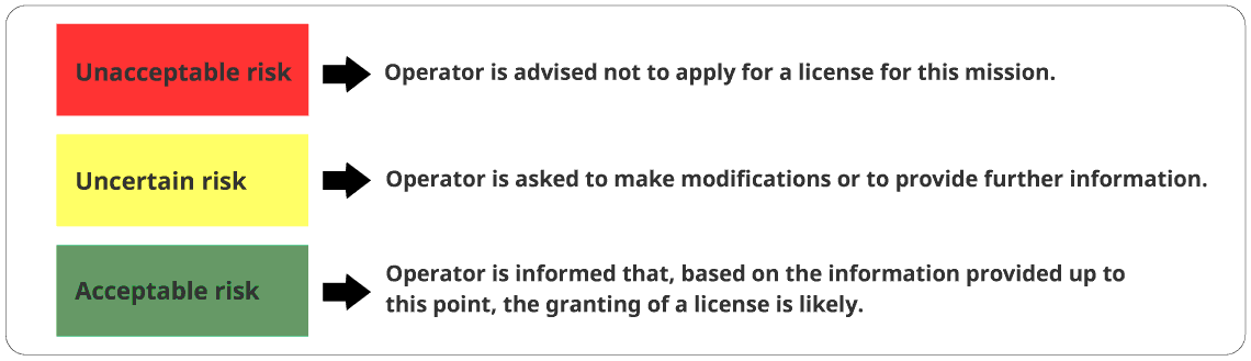
LONG DESCRIPTION: Figure 9 shows the License Screening Tool of the United Kingdom. It uses three colours for the three types of risks that help guide its screening of license applications.
- Red signifies Unacceptable risk - Operator is advised not to apply for a license for this mission.
- Yellow signifies Uncertain risk - Operator is asked to make modifications or to provide further information.
- Green signifies Acceptable risk - Operator is informed that, based on the information provided up to this point, the granting of a license is likely.
11. Conclusions
Based on our understanding of government mandates, space remote sensing technologies and businesses, and our extensive consultation with stakeholders in industry, academia, and government, SSCL draws the following conclusions about the RSSSA:
11.1. Operation of the RSSSA
- The RSSSA provides an effective set of tools for government regulators to exercise any required control over remote sensing space systems operated by Canadians worldwide and foreign operators in Canada.
- As required by the Act, the regulator places the highest priority on mitigating any potential security or foreign policy risks from proposed remote sensing space systems, when licensing such systems.
- Recent international technological and business developments, especially the proliferation of large numbers of global commercial remote sensing space systems, means that the strict regulation of a small number of such systems under the RSSSA provides little meaningful security or foreign policy benefits to Canada. Canadian regulation of remote sensing space systems can be safely relaxed.
- Implementing the requirements of the RSSSA creates incremental costs and complexity for the Canadian space industry and R&D organizations. Such incremental costs and complexity inhibit innovation and disadvantage Canadian businesses with respect to international competitors.
- Canada risks falling behind other international jurisdictions that either have no restrictive space remote sensing regulations, or, like the United States, are liberalizing their RSSSA-equivalent regulations to promote their remote sensing space industries and prioritize innovation and commercialization of space remote sensing information.
- Despite gaps in the relevant regulatory regimes, including in the RSSSA, Canada meets its international obligations with respect to space remote sensing.
11.2. Administration of the RSSSA
It is a major thesis of this Independent Review that Canadian regulation of remote sensing space systems under the RSSSA can and should be reduced. However, unless and until required changes to space remote sensing legislation and regulations are made, GAC must continue to operate under the existing legal framework. The Review team, therefore, assessed GAC’s administration of the Act in light of the current regulatory requirements.
GAC has done excellent work administering the RSSSA. This is true despite the complications and contradictions that GAC faces in implementing legislation that is increasingly outdated and arguably irrelevant in the emerging global marketplace of ubiquitous, lightly-regulated space remote sensing. Most of GAC’s RSSSA licencing clients speak favourably of GAC’s efforts to support them. Licences have been issued, for the most part, in a timely fashion. Nevertheless, GAC faces significant challenges:
- GAC’s workload – the number of RSSSA licence and amendment requests and other inquiries – has increased exponentially as more Canadian businesses and R&D organizations bring forward new and innovative remote sensing space systems and new partnership forms.
- The technical, legal, and policy issues associated with administering the RSSSA are increasingly complex.
- The resources applied to administer the RSSSA, especially numbers of personnel, are not increasing in step with the increased workload.
- GAC’s ability to provide its small number of space personnel with appropriate training, professional development, and career advancement is limited. For example, experienced licensing officers do not typically compete for senior positions that are typically occupied by rotational foreign service officers, e.g., the Deputy Director of Space position.
11.3. Canadian Space Governance
The RSSSA exists within the context of an incoherent Canadian space governance structure. Various government mandates – touching on space issues to one degree or another – operate independently of one another. Sometimes these mandates operate at cross-purposes or fail to support and reinforce one another. Canadian space innovators are faced with a complex and confusing government bureaucracy when creating, licensing, and operating new space technologies.
- Canadian space innovation and commercialization efforts would benefit greatly from a “one-stop shop” for the relevant government oversight and support.
- Canada needs a comprehensive General Space Law and a National Space Policy to harmonize and harness the power of government in delivering innovation in space technologies and information for the benefit of all Canadians.
11.4. Emerging Regulatory Issues
Current and emerging technology trends are raising new potential regulatory concerns that government may need to address, perhaps using the RSSSA, new comprehensive space legislation, or other tools (e.g., export controls, Controlled Goods procedures).
- Data, from space and elsewhere, has been integrated into all aspect of everyday life. Any interruptions to the availability of data can be catastrophic. Regulations may be needed to safeguard Canadians against data interruptions.
- Giving every stakeholder access to the same accurate, timely information – democratized EO data – can raise the level of public discourse and help communities make better-informed decisions. Regulations should facilitate democratized data.
- With the proliferation of EO sensors, companies are striving to be the first to implement a fully functional, near-constant monitoring of Earth at a very fine resolution. Regulations may be needed to protect the privacy of Canadians in the face of this ubiquitous surveillance from space.
12. Recommendations
12.1. Short-Term Recommendations
Recommendation 1: Review the Policy Goals of the RSSSA and adjust Regulatory Practice
GAC should lead a formal interdepartmental review of the policy goals of the RSSSA to balance and reconcile Canadian national security and foreign policy interests with the economic development, innovation, and global competitiveness interests of the country.
The review should include a wide range of government stakeholders, not just those with national security and foreign policy mandates. To the maximum extent possible, the review should include representatives from industry and other interested parties. Expertise required for the review includes:
- national security and foreign policy
- economic development and regional development
- science and innovation
As much as possible, given the restricted nature of information about some security-related issues, the review should be conducted in public and its results published.
The review should:
- determine what national security and foreign policy risks that government believes are being mitigated through the licensing of remote sensing space systems under the RSSSA, for example:
- not revealing location and status information about Canadian Forces
- not allowing analysis of weaknesses in Canadian critical infrastructure
- whether “new” data types should be controlled under the RSSSA, for example:
- Space-based ship Automatic Identification System (AIS) and aircraft Automatic Dependent Surveillance-Broadcast (ADS-B) data (i.e., space-based collection of position and other information broadcast by ships and aircraft)
- Space-based Space Situational Awareness (SSA) data (i.e., information collected by a satellite about the position and status of other satellites in space)
Results of the review should include:
- identifying and, as far as possible, publishing “standard” exemptions to the provisions of the RSSSA that are judged to be acceptable for various licensing scenarios
- applying “standard” exemptions to the provisions of the RSSSA to new and existing licences under the Act
- identifying and implementing processes, procedures, and additional support to ensure disadvantaged communities (e.g., those in the North and First Nations) are not hindered by the unintended consequences of the RSSSA and can fully benefit from space remote sensing information. This could include targeted outreach to disadvantaged communities and financial aid for the RSSSA licencing process.
- identifying formal Class Exemptions Footnote 51 to be implemented using the Minister’s authority under the RSSSA
- identifying proposed amendments to the RSSSA and the RSSS Regulations
Recommendation 2: Continue the ongoing work to improve the RSSSA licensing process
GAC should further improve the RSSSA licensing process, including streamlining and automating some aspects of the licence application process. This should both improve the licensing experience for prospective licensees and make more efficient use of GAC resources (e.g., answering typical questions via an online tool rather than by discussion with licensing officers.) Steps should include:
- establishing an online pre-assessment questionnaire for potential applicants to determine if they need a licence under the RSSSA
- automating the licence application process as much as is practically possible
- developing workshops and videos to assist the licensee with the application process
Recommendation 3: Establish a permanent RSSSA Advisory Committee
- make the Ad Hoc RSSSA Advisory Committee permanent
- expand public outreach to address other rapidly advancing technologies that impact the regulation of space remote sensing, such as cloud computing, Artificial Intelligence, and Quantum technology. Include additional RSSSA Advisory Committee attendees as appropriate when attending industry events.
- institute periodic broad public consultations to address important issues in the development of space remote sensing technologies and regulations
12.2. Medium-Term Recommendations
Recommendation 4: Make further improvements to the Administration of the RSSSA by GAC
- ensure appropriate resources are available as the RSSSA licensing workload increases to respond to the rise in the number of licence inquiries and applications (along with the ongoing revolution in space activities). Resources should include funding for more policy and licence officers and opportunities for staff training, professional development, and career progression to encourage and retain expertise.
- create a position for a permanent expert space manager to support the RSSSA team (i.e., as an advisor to, or replacement for the rotational foreign service officer serving as Deputy Director of Space)
Recommendation 5: Create a “One-Stop Shop” for Government oversight and support of Space
The Government should name a lead Department or Agency to:
- establish an online portal that integrates Canadian space licensing and support activities, independent of any one government department. The public-facing regulatory process should be seamless, regardless of departmental jurisdiction.
Recommendation 6: Amend the RSSS Regulations
GAC should lead the interdepartmental process to:
- amend the RSSS Regulations as appropriate, for example to implement Class Exemptions to the RSSSA, based on the results of the interdepartmental review of the policy goals of the RSSSA (Recommendation 1 above)
12.3. Long-Term Recommendations
Recommendation 7: Create a Cabinet-level Space Committee
The Government should institute a Cabinet-level committee with executive oversight of the space portfolio, similar to the U.S. National Space Council chaired by the U.S. Vice President.
Recommendation 8: Conduct a Whole of Government / Industry / Academia Review of Canadian Space Policy
The Cabinet Space Committee should give direction for a Space Policy Review to assess and reorder Canada’s priorities for space. Harnessing space for the benefit of Canada should be the primary goal of Canadian space policy. As in other areas where technology is advancing quickly, industry and academia must be at the table with government for the policy review for government to fully understand the state of the art and its impact.
Recommendation 9: Develop and Publish a National Space Policy for Canada
The Government should develop and publish a National Space Policy, based on the results of the Space Policy Review (Recommendation 8 above).
Recommendation 10: Amend or Replace the RSSSA
The Government and Parliament should amend or replace the RSSSA, based on the results of the review of the policy goals of the RSSSA (Recommendation 1 above) and the Space Policy Review (Recommendation 8 above).
Recommendation 11: Create a comprehensive Canadian General Space Act
The Government and Parliament should create a comprehensive General Space Act, based on the results of the Space Policy Review (Recommendation 8 above).
13. List of Abbreviations and Acronyms
Acronym Description ACCRES Advisory Committee on Commercial Remote Sensing (United States) ADS-B Automatic Dependent Surveillance-Broadcast (information broadcast by aircraft) AI Artificial Intelligence AIS Automatic Identification System (information broadcast by ships) CSA Canadian Space Agency CSE Communications Security Establishment (Canada) COPUOS Committee on the Peaceful Uses of Outer Space (UN) DFAIT Department of Foreign Affairs and International Trade (Canada) DND Department of National Defence (Canada) DoC Department of Commerce (United States) EO Earth Observation GAC Global Affairs Canada GoC Government of Canada HSI Hyperspectral Imaging IADC Inter-Agency Space Debris Coordination Committee InSAR Interferometric Synthetic Aperture Radar ISED Innovation, Science and Economic Development Lidar Light detection and ranging LTS Long-term sustainability MOEMS Micro-Opto-Electro-Mechanical Systems NATO North Atlantic Treaty Organization NOAA National Oceanic and Atmospheric Administration (United States) NORAD North American Aerospace Defense Command OST Outer Space Treaty PBR Passive Bistatic Radar PNT Positioning, Navigation, and Timing PolInSAR Polarimetric synthetic-aperture radar interferometry QKD Quantum Key Distribution RCM Radarsat Constellation Mission RSSSA Remote Sensing Space Systems Act RSSS Regulations Remote Sensing Space Systems Regulations SAL Synthetic Aperture Lidar SAR Synthetic Aperture Radar SatDSiG The National Data Security Policy for Space-Based Earth Remote Sensing Systems
(Germany)SPA System Participant Agreement SSCL Space Strategies Consulting Ltd. TRL Technology Readiness Level TTPs Tactics, Techniques, and Procedures UAV Unmanned Aerial Vehicle UN United Nations UNGA United Nations General Assembly Annex A - Replies to the RSSSA Stakeholder Questionnaire
RSSSA Stakeholder Questionnaire
Canada's Remote Sensing Space Systems Act (RSSSA) has been an important regulatory tool for the Government of Canada and a licencing reality for Canada's remote sensing space industry since the Act came into force in 2007.
The RSSSA requires that an Independent Review of the Act be conducted every five years -- Global Affairs Canada has selected Space Strategies Consulting Limited (SSCL) to conduct the 2022 Independent Review of the RSSSA. This review comes at an important time for Canada's remote sensing space industry, as it experiences dramatic changes in technology, business models and international competition, as part of the broad ongoing revolution in the global commercial space economy.
The Independent Review of the RSSSA is a unique opportunity for all stakeholder communities to effectively communicate their views about the current status and desired future of the RSSSA to senior government officials, Ministers and Parliamentarians.
This RSSSA Stakeholder Questionnaire is a key first step for the Independent Review team to engage with the full range of RSSSA stakeholders.
- All stakeholders are encouraged to reply to this questionnaire
- Some stakeholders may only have experience or expertise in certain areas of the questionnaire.
- Partial responses to the questionnaire are therefore welcome and expected.
The sections of the questionnaire are:
- Introductory Questions
- Your Knowledge of the RSSSA
- Policy Goals of the RSSSA (including national security)
- Facilitating Industry
- Issues Surrounding Data
- The RSSSA and Canada's International Obligations
- Administration of the RSSSA
- Other Issues Related to the RSSSA (e.g., National Space Policy)
- Follow-on Communication and questionnaire submission
Completing the full questionnaire should take approximately 30 minutes
The review team also welcomes any additional inputs or submissions stakeholders may wish to provide by email to: rsssa@sscl.solutions
We thank all concerned in advance for the invaluable contribution of their time and expertise towards the best interests of Canada's remote sensing space industry and the Government of Canada.
Section 1 - Introductory Questions
Note that the Report of the Independent Review of the RSSSA will be a public document tabled in Parliament. However, the contents of the report will be anonymized and will not name any specific stakeholder consulted by the review team. Global Affairs Canada will be provided a separate list of the names of stakeholders actually consulted by the review team.
SSCL is prepared to enter into formal non-disclosure agreements with any stakeholders who wish to do so for any portion of their engagement with SSCL as part of the Independent Review.
- What is your name? 37 Responses
- Which organization do you represent? 37 Responses
- What is your job title? 37 Responses
- Please select the category that best describes your organization
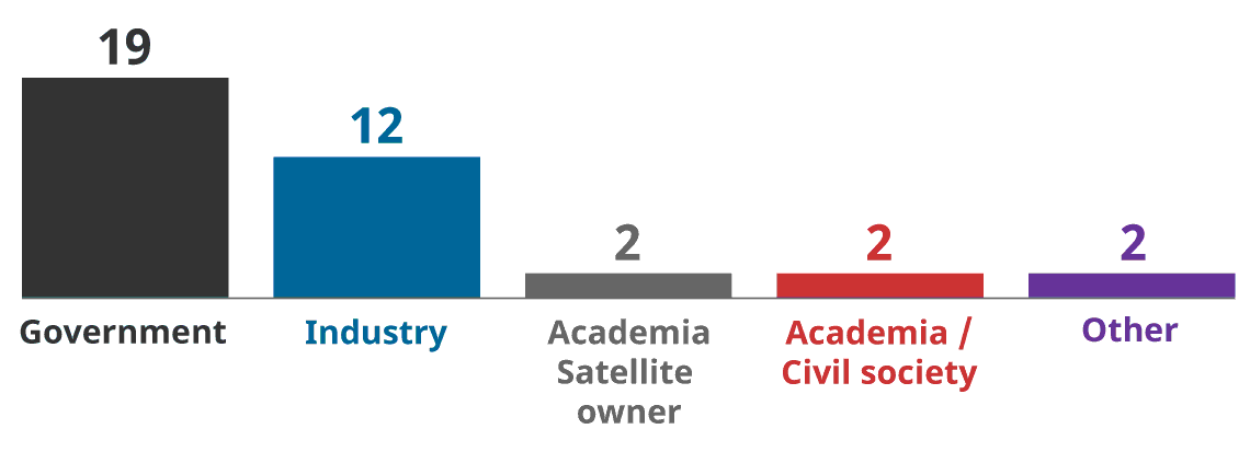
- Government of Canada = 19
- Industry = 12
- Academia - Satellite owner = 2
- Academia/Civil Society = 2
- Other = 2
- Foreign Government = 0
Section 2 - Your Knowledge of the RSSSA
Please describe your level of involvement with the RSSSA
- My knowledge of the regulation of space-based remote sensing systems by the Government of Canada and other governments is:

- My knowledge of Canada's Remote Sensing Space Systems Act is:
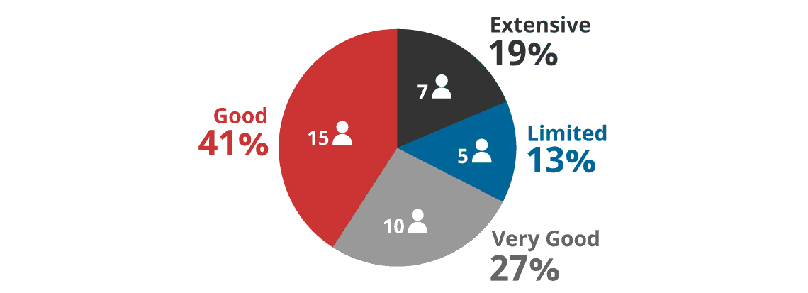
- Please rate your response to the following statements
Have you or your organization actively considered a potential application for a licence under the RSSSA?

Have you or your organization formally applied for a licence under the RSSSA?

Have you or your organization been granted a licence under the RSSSA?

Have you ever been part of the government team reviewing RSSSA licence applications?

Section 3 - Policy Goals of the RSSSA
The RSSSA provides for the licencing of remote sensing space systems, having regard to:
- National Security
- The defence of Canada
- The safety of Canadian Forces
- Canada’s conduct of international relations
- Canada’s international obligations; and
- Any prescribed factors.
The Remote Sensing Space System Regulations list two (2) prescribed factors:
- The ability of the applicant to comply with the Act and the Regulations; and
- The enhancement of the competitiveness, at the national and international levels, of the Canadian remote sensing space industry
This section seeks comments on the continuing relevance and importance of the policy goals of the RSSSA.
For your reference if required:
- The text of the RSSSA is at: https://laws-lois.justice.gc.ca/eng/acts/R-5.4/
- The text of the RSSS Regulations is at: https://laws-lois.justice.gc.ca/eng/regulations/SOR-2007-66/index.html
- Do you have any comments on the policy goals of the RSSSA?
- Select "Yes" to see the questions in this section.
- Select "No" and "Next" to skip to the next section.

Breakdown of the 27 responses to Section 3 by stakeholder type:

- Government of Canada = 14
- Industry = 9
- Academia – Satellite owner = 1
- Academia/Civil Society = 2
- Other = 1
- The remote sensing space system activities governed by the RSSSA should continue to be regulated by government to support Canada’s conduct of international relations and meeting its international obligations.

- Strongly agree = 48% (13)
- Agree = 33% (9)
- Disagree = 8% (2)
- Strongly disagree = 11% (3)
- Don’t know = 0% (0)
- How useful are the following controls (that can be imposed under the RSSSA) in meeting the policy goals of the RSSSA?
Customer Access Profiles (CAPs)
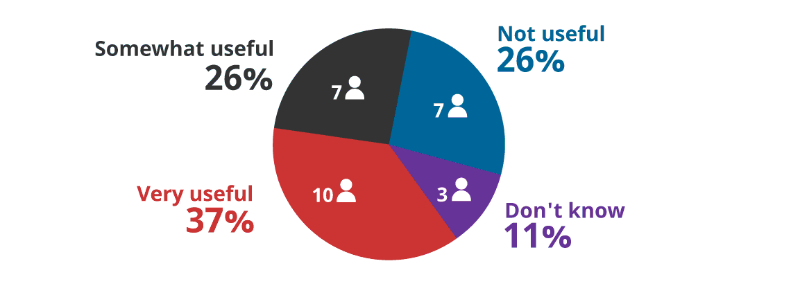
- Very Useful = 37% (10)
- Somewhat useful = 26% (7)
- Not useful = 26% (7)
- Don’t know = 11% (3)
Interruptions of Service (aka “Shutter Control”)

- Very Useful =18% (5)
- Somewhat useful = 36% (10)
- Not useful = 30% (8)
- Don’t know = 15% (4)
Priority Access
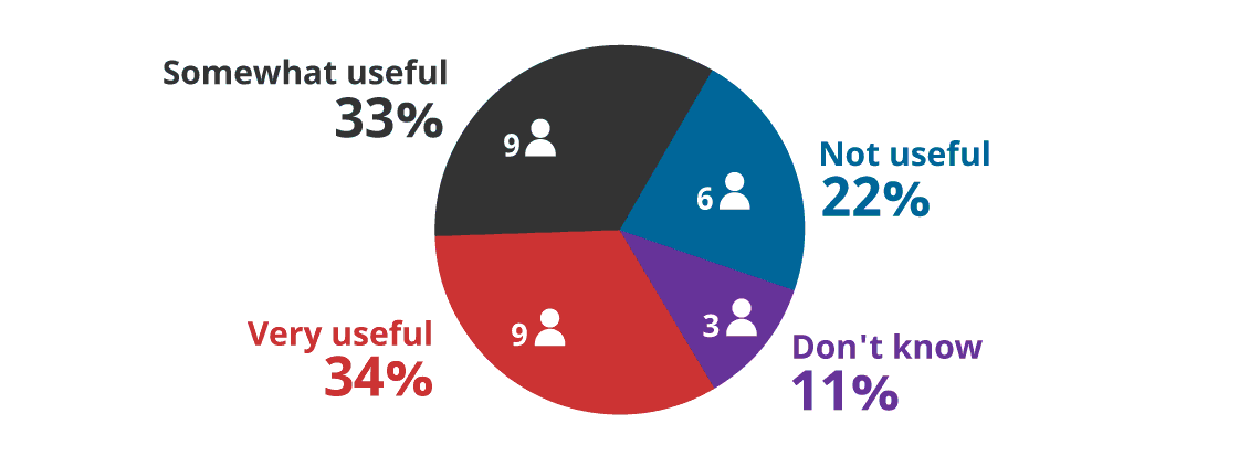
- Very Useful = 34% (9)
- Somewhat useful = 33% (9)
- Not useful = 22% (6)
- Don’t know = 11% (3)
- There is a large and growing number of increasingly sophisticated international commercial remote sensing space systems, some of which may not be regulated to the same degree that similar Canadian systems are regulated. For example, under the RSSSA, Canada can limit some sales of commercial remote sensing space information based on the area of the Earth sensed or on customer profiles. Some other space-faring nations may not place such controls on sales of commercial remote sensing space information. Please rate your agreement with the following statement:
Canada’s regulation of Canadian remote sensing space systems is no longer an effective tool for national security, the defence of Canada, and the safety of Canadian Forces. (For example, prohibiting the sale of information from imaging of areas on the surface of the Earth considered to be sensitive (e.g., areas of some military operations) is not effective, given that similar information is available from other international sources.)

- Strongly agree = 22% (6)
- Agree = 15% (4)
- Disagree = 48% (13)
- Strongly disagree = 8% (2)
- Don’t know = 7% (2)
- If you believe the RSSSA is no longer an effective tool for national security, the defence of Canada, and the safety of the Canadian Forces, please describe why:
- 13 Free Text Responses (not reproduced here to preserve stakeholder anonymity)
- If you believe the RSSSA continues to be an effective tool for national security, the defence of Canada and the safety of the Canadian Forces, please describe why:
- 17 Free Text Responses (not reproduced here to preserve stakeholder anonymity)
- New types of remote sensing space systems and the new types of data they produce (e.g., Space Situation Awareness (SSA), space-based ship Automatic Identification System (AIS) and aircraft Automatic Dependent Surveillance–Broadcast (ADS-B), other commercial “signals intelligence”, space-based bi-static radar, etc.) may or may not be subject to the RSSSA, depending upon various interpretations of the Act’s definition of a “remote sensing satellite.” Please rate your agreement with the following statements:
New types of commercial remote sensing space data (e.g., Space Situational Awareness, commercial signals intelligence, etc.) represent a legitimate policy concern for the Government of Canada.
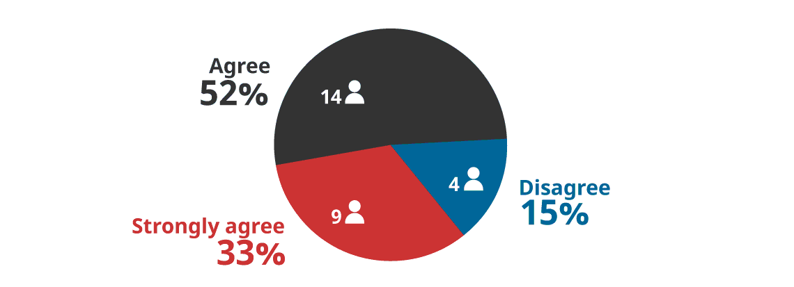
- Strongly agree = 33% (9)
- Agree = 52% (14)
- Disagree = 15% (4)
- Strongly disagree = 0% (0)
- Don’t know = 0% (0)
- Government should regulate new types of commercial remote sensing space data (e.g., Space Situational Awareness, commercial signals intelligence, etc.)
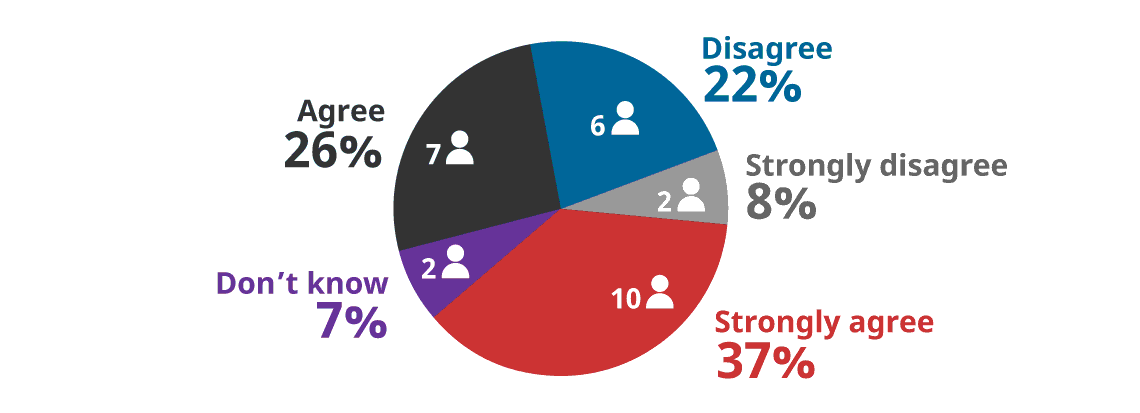
- Strongly agree = 8% (10)
- Agree = 26% (7)
- Disagree = 22% (6)
- Strongly disagree = 8% (2)
- Don’t know = 7% (2)
- The RSSSA gives the Minister the authority to exempt persons, systems etc. from the application of the RSSSA. Such “Class Exemptions” are one potential mechanism to adjust the policy approaches implemented by government under the RSSSA. Please comment on the possible use of RSSSA Class Exemptions as follows
Certain commercial remote sensing space activities no longer represent a risk to Canada’s national security, etc. and should be exempted from application of the RSSSA (e.g. via “Class Exemptions” ordered by the Minister.)
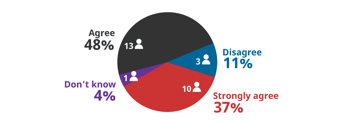
- Strongly agree = 37% (10)
- Agree = 48% (13)
- Disagree = 11% (3)
- Strongly disagree = 0% (0)
- Don’t know = 4% (1)
- Please identify what remote sensing space activities you believe should be exempted from application of the RSSSA and describe your rationale for such exemptions (e.g., sensor type, sensor resolution, area of coverage, availability of similar data from other sources, etc.) If you wish, more extensive input (e.g., supporting analysis for your rationale) can be emailed to the review team at: rsssa@sscl.solutions
- 23 Free Text Responses (not reproduced here to preserve stakeholder anonymity)
- If you have any additional comments concerning the policy goals of the RSSSA, please provide them below. If you wish, more extensive input can be emailed to the review team at: rsssa@sscl.solutions
- 16 Free Text Responses (not reproduced here to preserve stakeholder anonymity)
Section 4 -- The RSSSA and facilitating Canada's remote sensing space industry
In the operation of the RSSSA, government should strike an appropriate balance between meeting national security and foreign policy goals versus enhancing the competitiveness of Canada's remote sensing space industry. To help us understand the factors at play in striking the correct balance, please rate your agreement with the following statements:
- Do you have any comments on the role of the RSSSA in facilitating Canada's remote sensing space industry? (Select "Yes" to see the questions in this section. / Select "No" and "Next" to skip to the next section.)

Breakdown of the 31 responses to Section 4 by stakeholder type:
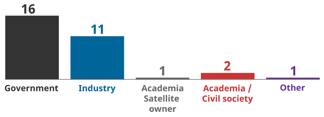
- Government of Canada = 16
- Industry = 11
- Academia – Satellite owner = 1
- Academia/Civil Society = 2
- Other = 1
- Implementing certain controls required under the RSSSA (e.g. Customer Access Profiles, Interruptions of Service, Priority Access, encryption) adds to the cost of designing, building and operating a remote sensing space system.

Question 21 - Response Breakdown by Stakeholder Group
Government Industry Academia
Satellite ownerAcademia
Space PolicyOther Total Yes 11 9 0 2 1 23 No 2 2 1 0 0 5 Don’t know 3 0 0 0 0 3 Total 16 11 1 2 1 31 - The incremental costs to ensure a remote sensing space system can provide various controls required under the RSSSA (e.g. enforce Customer Access Profiles, implement Interruptions of Service, Priority Access, encryption, etc.) are:
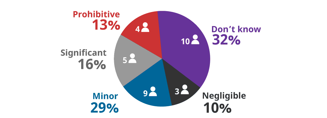
Question 22 - Response Breakdown by Stakeholder Group
Government Industry Academia
Satellite ownerAcademia
Space PolicyOther Total Negligible 1 1 1 0 0 3 Minor 5 3 0 1 0 9 Significant 1 3 0 1 0 5 Prohibitive 1 3 0 0 0 4 Don’t know 8 1 0 0 1 10 Total 16 11 1 2 1 31 - Please provide any additional comments you may have on the incremental costs to ensure a remote sensing space system can provide various controls required under the RSSSA.
- 20 Free Text Responses (not reproduced here to preserve stakeholder anonymity)
- The actual implementation of national security-related requirements under the RSSSA (e.g. Customer Access Profiles, encryption) has the following impact on the ability of business to develop and serve customers for remote sensing data and services:
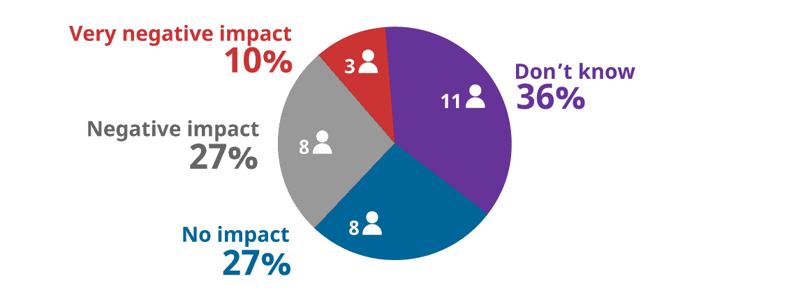
- No Impact = 27% (8)
- Negative impact = 27% (8)
- Very Negative impact = 10% (3)
- Don’t know = 36% (11)
* Note that one (1) respondent to this section of the
questionnaire did not answer this question.Question 24 - Response Breakdown by Stakeholder Group
Government Industry Academia
Satellite ownerAcademia
Space PolicyOther Total No impact 4 2 1 1 0 8 Negative impact 2 4 0 1 1 8 Very negative impact 0 3 0 0 0 3 Don’t know 9 2 0 0 0 11 No answer 1 0 0 0 0 1 Total 16 11 1 2 1 31 - The adverse business impact (e.g. lost customers, lost investors) of actual national security-related requirements imposed under the RSSSA (e.g. Customer Access Profiles, encryption) is:
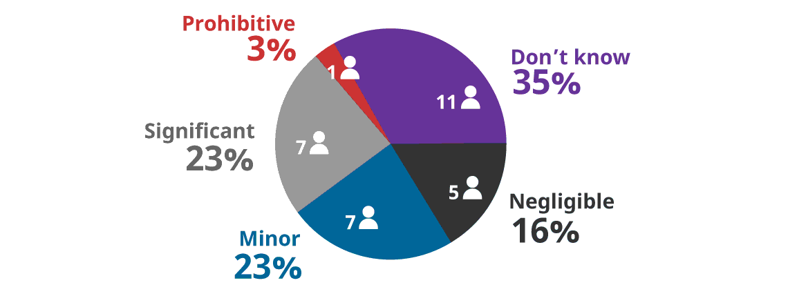
Question 25 - Response Breakdown by Stakeholder Group
Government Industry Academia
Satellite ownerAcademia
Space PolicyOther Total Negligible 3 0 1 1 0 5 Minor 3 4 0 0 0 7 Significant 1 5 0 0 1 7 Prohibitive 0 1 0 0 0 1 Don’t know 9 1 0 1 0 11 No answer 0 0 0 0 0 0 Total 16 11 1 2 1 31 - The potential for the government to issue orders under the RSSSA for Interruptions of Service or Priority Access has the following impact on the ability of business to develop and serve customers for remote sensing data and services:
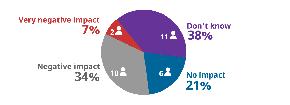
- No Impact = 21% (6)
- Negative impact = 34% (10)
- Very Negative impact = 7% (2)
- Don’t know = 38% (11)
* Note that some respondents to this section of the questionnaire did not answer this question.
Question 26 - Response Breakdown by Stakeholder Group
Government Industry Academia
Satellite ownerAcademia
Space PolicyOther Total No impact 2 2 1 1 0 6 Negative impact 4 5 0 0 1 10 Very negative impact 0 2 0 0 0 2 Don’t know 8 2 0 1 0 11 No answer 2 0 0 0 0 2 Total 16 11 1 2 1 31 - Please provide any additional comments you may have on the impact of national security requirements from the RSSSA on commercial remote sensing space companies.
- 16 Free Text Responses (not reproduced here to preserve stakeholder anonymity)
- In some circumstances, businesses may have options to choose what jurisdiction in which to have all, or part of a remote sensing space system licenced (for example, by choosing where to locate system ground stations). Please rate your agreement with the following statements:
There are business advantages in licencing space remote sensing systems in Canada under the RSSSA, as compared to other regulatory jurisdictions.

- Strongly agree = 3% (1)
- Agree = 23% (7)
- Disagree = 19% (6)
- Strongly disagree = 13% (4)
- Don’t know = 42% (13)
- If you wish, please describe the business advantages you see in licencing space remote sensing systems in Canada under the RSSSA.
- 15 Free Text Responses (not reproduced here to preserve stakeholder anonymity)
- The space remote sensing regulatory environment in jurisdictions other than Canada provides business advantages for space remote sensing companies, as compared to Canada's regulation of space remote sensing under the RSSSA.

- Strongly agree = 23% (7)
- Agree = 35% (11)
- Disagree = 13% (4)
- Strongly disagree = 0% (0)
- Don’t know = 29% (9)
- If you wish, please describe the business advantages you see in the space remote sensing regulatory environment in jurisdictions other than Canada.
- 16 Free Text Responses (not reproduced here to preserve stakeholder anonymity)
- Research and Development (R&D) activities are key to technical and economic progress for Canada’s space remote sensing industry. Such activities may involve the launch and operation of test/prototype satellites and/or the early implementation of systems with limited capabilities to be replaced with later, more capable systems. The following questions explore the impact of the RSSSA on satellite R&D activities.
Are test and prototype satellites an area of development/concern for you or your organization
- Yes = 19
- No = 5
- Not Applicable = 7
- Does your or your organization's development approach include incremental capability growth in blocks of satellites launched over months and years.
- Yes = 13
- No = 4
- Not Applicable = 13
- In your experience, what impact do the RSSSA, RSSS Regulations and typical regulatory practice have on satellite R&D and incremental system deployments:

- No Impact = 26% (8)
- Negative impact = 26% (8)
- Very Negative impact = 6% (2)
- Don’t know = 42% (13)
- Certain satellite R&D activities should be exempted from application of the RSSSA (e.g. via Class Exemptions ordered by the Minister.)
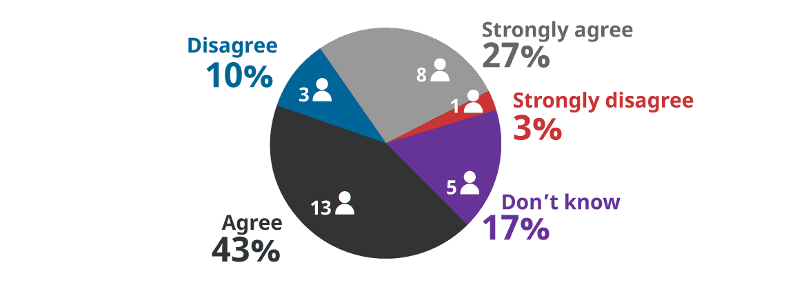
- Strongly agree = 27% (8)
- Agree = 43% (13)
- Disagree = 10% (3)
- Strongly disagree = 3% (1)
- Don’t know = 17% (5)
- Please describe what R&D activities you believe should be exempted from application of the RSSSA and describe your rationale for such exemptions. If you wish, more extensive input (e.g., supporting analysis for your rationale) can be emailed to the review team at: rsssa@sscl.solutions
- 22 Free Text Responses (not reproduced here to preserve stakeholder anonymity)
- In a regulatory context, what other action(s) would you recommend government take to facilitate the development of Canada's remote sensing space industry?
- 22 Free Text Responses (not reproduced here to preserve stakeholder anonymity)
- Please provide any additional comments you may have concerning the impact of the RSSSA on Canada's remote sensing space industry. If you wish, more extensive input can be emailed to the review team at: rsssa@sscl.solutions
- 11 Free Text Responses (not reproduced here to preserve stakeholder anonymity)
Section 5 - Issues surrounding data: Definitions, "Transformation", Cloud Computing and Cloud Storage
Many of the technical concepts and definitions in the RSSSA are oriented towards radar remote sensing systems. These concepts and definitions were useful in the early operation of the RSSSA (for example in licencing Radarsat), but they may not be well suited to other types of remote sensing systems (e.g. optical, hyper-spectral, etc.)
In addition, new data handling concepts and concerns have become more prominent since the creation of the RSSSA, such as:
- Cloud storage
- Cloud computing
- Open data
- Information protection and information assurance
- Aggregation of multiple data sources to produce end-products, etc.
These new data handling concepts and techniques may not fit easily into the regulatory framework originally envisioned by the RSSSA.
Your answers to the questions below will help us understand the impact of these issues.
For your reference if required:
- The text of the RSSSA is at: https://laws-lois.justice.gc.ca/eng/acts/R-5.4/
- The text of the RSSS Regulations is at: https://laws-lois.justice.gc.ca/eng/regulations/SOR-2007-66/index.html
- Do you have any comments on data issues and the RSSSA? (Select "Yes" to see the questions in this section. / Select "No" and "Next" to skip to the next section.)

Breakdown of the 28 responses to Section 5 by stakeholder type:

- Government of Canada = 13
- Industry = 11
- Academia – Satellite owner = 2
- Academia/Civil Society = 0
- Other = 2
- The definitions of "transformation", "raw data", and "remote sensing products" in the Act and the Regulations and their implementation in practice are well suited to my activities.

- Strongly agree = 0% (0)
- Agree = 22% (6)
- Disagree = 32% (9)
- Strongly disagree = 21% (6)
- Don’t know = 25% (7)
- Data handling requirements imposed under the RSSSA (e.g. for the control of “raw data”) have the following impact on the ability of business to adopt the data handling practices (e.g., cloud storage, cloud computing, aggregation of multiple data sources to produce end-products, etc.) that are key to the success of a modern remote sensing space system business:
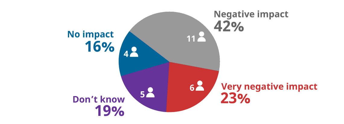
- No Impact = 16% (4)
- Negative impact = 42% (11)
- Very Negative impact = 23% (6)
- Don’t know = 19% (5)
- The provisions of the RSSSA are well suited to the implementation of modern information protection and information assurance concepts and techniques.

- Strongly agree = 7% (2)
- Agree = 25% (7)
- Disagree = 39% (11)
- Strongly disagree = 18% (5)
- Don’t know = 11% (3)
- Please provide any additional comments you may have concerning the impact of data definitions and modern data handling concepts on the functioning of the RSSSA. If you wish, more extensive input can be emailed to the review team at: rsssa@sscl.solutions
- 16 Free Text Responses (not reproduced here to preserve stakeholder anonymity)
Section 6 - The RSSSA and Canada's international obligations
In general, international obligations with respect to space remote sensing stem from U.N. space treaties, agreements and guidelines.
For your information, Global Affairs Canada provides some background on space policy here:
The Independent Review of the RSSSA will include an assessment of whether Canada is meeting international obligations. We are soliciting comments from any interested stakeholders, including space law and policy practitioners, to inform our analysis of this issue.
- Do you have any comment on the RSSSA and Canada's international obligations? (Select "Yes" to see the questions in this section. / Select "No" and "Next" to skip to the next section.)

Breakdown of the 25 responses to Section 6 by stakeholder type:
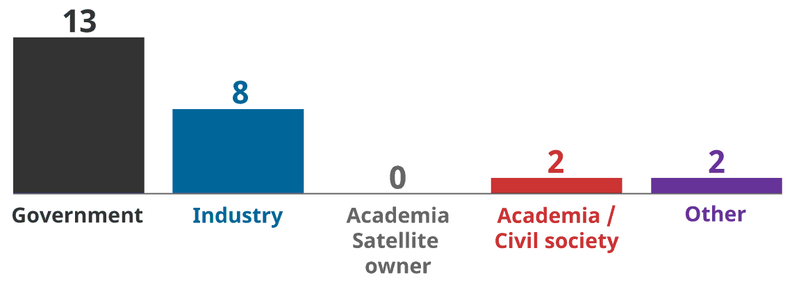
- Government of Canada = 13
- Industry = 8
- Academia – Satellite owner = 0
- Academia/Civil Society = 2
- Other = 2
- Please rate your agreement with the following statements:
Canada meets its international obligations concerning remote sensing under the UN space treaties, agreements and guidelines
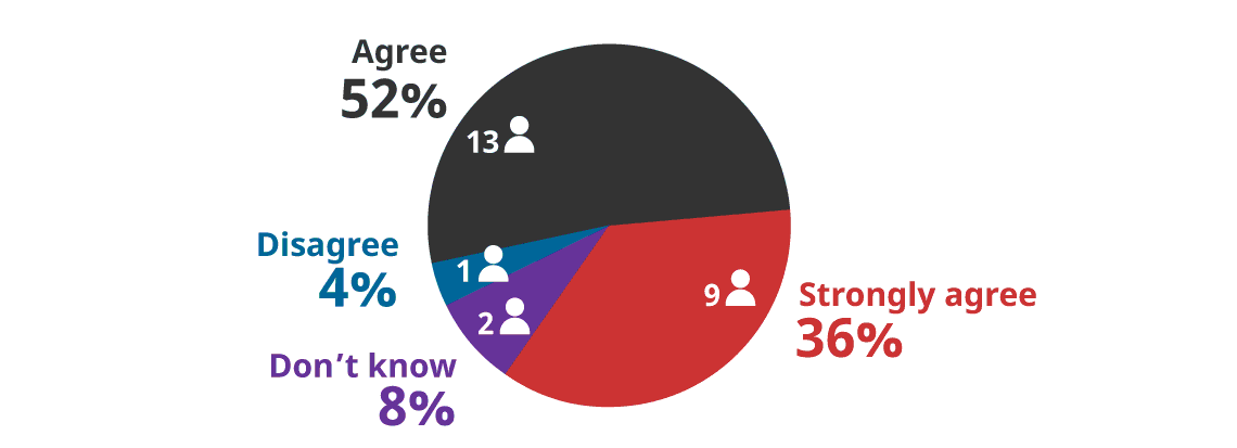
- Strongly agree = 36% (9)
- Agree = 52% (13)
- Disagree = 4% (1)
- Strongly disagree = 0% (0)
- Don’t know = 8% (2)
The RSSSA is a useful tool in allowing Canada to meet its international obligations under the UN space treaties, agreements and guidelines

- Strongly agree = 28% (7)
- Agree = 56% (14)
- Disagree = 4% (1)
- Strongly disagree = 12% (3)
- Don’t know = 0% (0)
The RSSSA is a useful tool in allowing Canada to meet its international obligations within NATO and NORAD
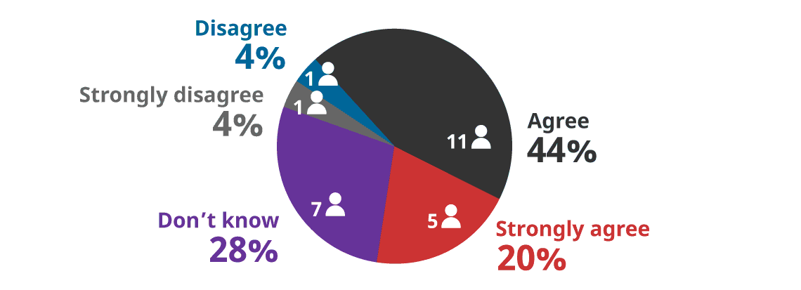
- Strongly agree = 20% (5)
- Agree = 44% (11)
- Disagree = 4% (1)
- Strongly disagree = 4% (1)
- Don’t know = 28% (7)
- Please provide any additional comments you may have concerning the contribution of the RSSSA to Canada's ability to meet its international obligations. If you wish, more extensive input can be emailed to the review team at: rsssa@sscl.solutions
10 Free Text Responses (not reproduced here to preserve stakeholder anonymity)
Section 7 - Administration of the RSSSA
This section addresses the practical functions of the RSSSA licencing process and GAC's engagement with Canada's space remote sensing community.
- Do you have any comments on the administration of the RSSSA? (Select "Yes" to see the questions in this section. / Select "No" and "Next" to skip to the next section.)

Breakdown of the 27 responses to Section 7 by stakeholder type:
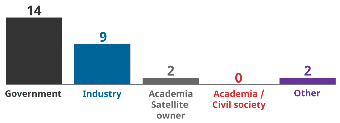
- Government of Canada = 14
- Industry = 9
- Academia – Satellite owner = 2
- Academia/Civil Society = 0
- Other = 2
- Please rate your agreement with the following statements:
It is clear to me if and why the RSSSA applies to my activities.

- It is clear to me what information is required in an application for a licence under the RSSSA.

- Strongly agree = 11% (3)
- Agree = 52% (14)
- Disagree = 11% (3)
- Strongly disagree = 4% (1)
- Don’t know = 22% (6)
- The process to apply for a licence under the RSSSA is straightforward.
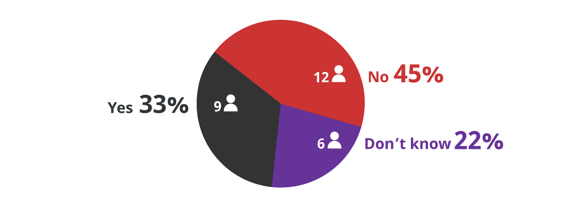
- The following is a link to the Global Affairs Canada RSSSA licence application guide. How useful is this document?
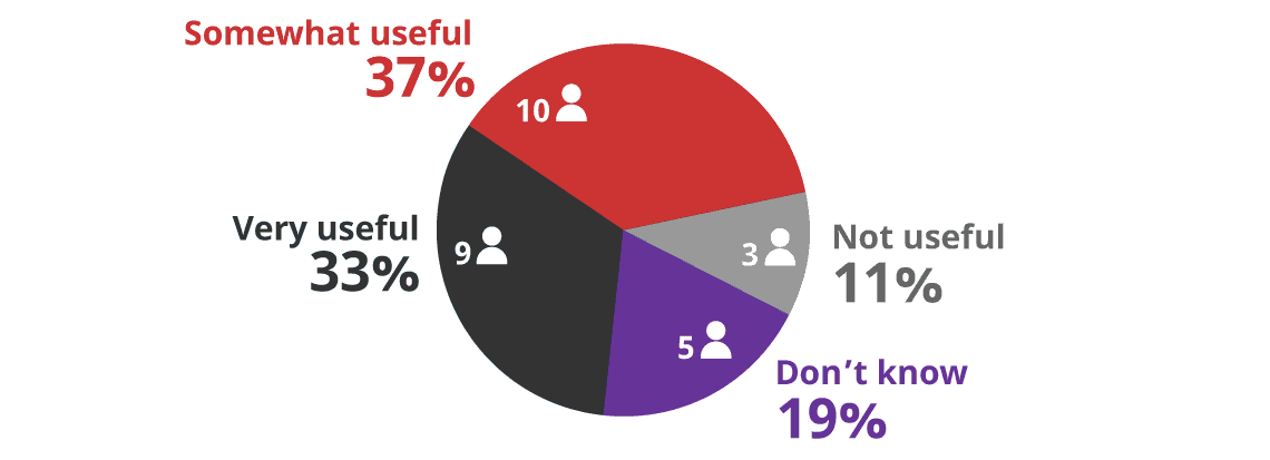
- Very Useful = 33% (9)
- Somewhat useful = 37% (10)
- Not useful = 11% (3)
- Don’t know = 19% (5)
- Please specify what additional information you would like to see in the RSSSA Operating Licence Application Guide (Part 1) or the guide to the RSSSA (Part 2) of the Client Procedures Circular (CPC). If you wish, more extensive input can be emailed to the review team at: rsssa@sscl.solutions
9 Free Text Responses (not reproduced here to preserve stakeholder anonymity)
- Please comment on the process to review and approve a licence under the RSSSA:
The process for approving a licence under the RSSSA is clear and transparent
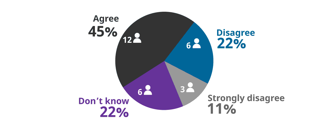
- Strongly agree = 0% (0)
- Agree = 45% (12)
- Disagree = 22% (6)
- Strongly disagree = 11% (3)
- Don’t know = 22% (6)
Global Affairs Canada was approachable, helpful and responsive in dealing with my application for a licence under the RSSSA

- Strongly agree = 31% (8)
- Agree = 27% (7)
- Disagree = 8% (2)
- Strongly disagree = 0% (0)
- Don’t know = 34% (9)
Replies from GAC concerning my application for a licence were useful and timely
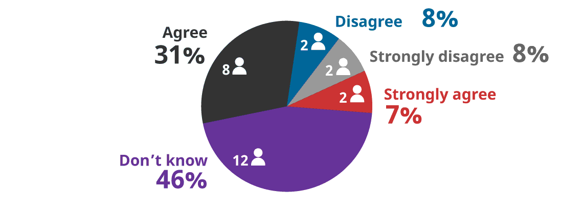
- Strongly agree = 7% (2)
- Agree = 31% (8)
- Disagree = 8% (2)
- Strongly disagree = 8% (2)
- Don’t know = 46% (12)
My licence under the RSSSA was granted in a timely fashion

- Strongly agree = 7% (2)
- Agree = 15% (4)
- Disagree = 19% (5)
- Strongly disagree = 15% (4)
- Don’t know = 44% (12)
- The ongoing administration of my licence under the RSSSA is reasonable and does not unduly burden my business (e.g. required reports, compliance inspections, etc.)
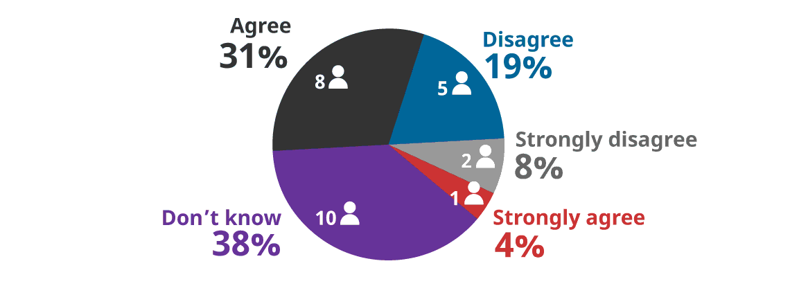
- Strongly agree = 4% (1)
- Agree = 31% (8)
- Disagree = 19% (5)
- Strongly disagree = 8% (2)
- Don’t know = 38% (10)
- The process to make changes to my licence under the RSSSA (e.g. to add a system participant) is reasonable, timely and not unduly burdensome.

- Strongly agree = 4% (1)
- Agree = 18% (5)
- Disagree = 19% (5)
- Strongly disagree = 7% (2)
- Don’t know = 52% (14)
- Are you aware of the Ad Hoc RSSSA Advisory Committee?

- Have you ever participated in the Ad Hoc RSSSA Advisory Committee?

- How useful is the Ad Hoc RSSSA Advisory Committee?
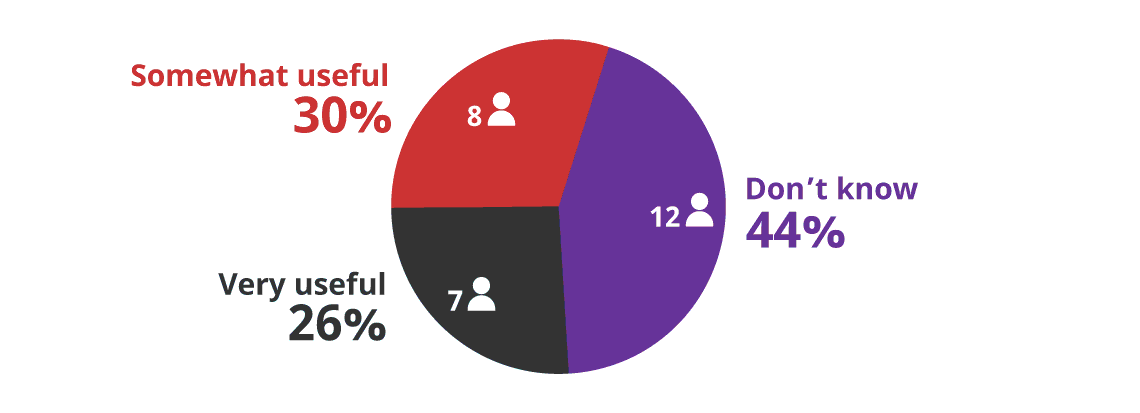
- Very Useful = 26% (7)
- Somewhat useful = 30% (8)
- Not useful = 0% (0)
- Don’t know = 44% (12)
- Should there be a permanent RSSSA Advisory Committee, including regular public meetings with of a range of RSSSA stakeholders?
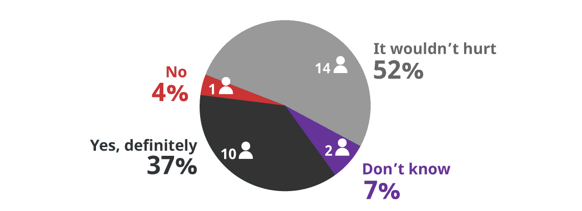
- Yes, definitely = 37% (10)
- It wouldn’t hurt = 52% (14)
- No = 4% (1)
- Don’t know = 7% (2)
- The following is a link to the GAC website for the RSSSA. How useful is the format and content of this website?

- Very Useful = 19% (5)
- Somewhat useful = 48% (13)
- Not useful = 7% (2)
- Don’t know = 26% (7)
- What changes would you like to see in the GAC website for the RSSSA? If you wish, more extensive input can be emailed to the review team at: rsssa@sscl.solutions
6 Free Text Responses (not reproduced here to preserve stakeholder anonymity)
Section 8 - Other Issues Related to the RSSSA
- Would you like to comment on other issues related to the RSSSA (e.g. Canadian Space Policy, etc.)? (Select "Yes" to see the questions in this section. / Select "No" and "Next" to skip to the next section.)

Breakdown of the 25 responses to Section 8 by stakeholder type:
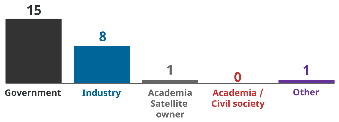
- Government of Canada = 15
- Industry = 8
- Academia - Satellite owner = 1
- Academia/Civil Society = 0
- Other = 1
- When licencing a space system in Canada, having to deal with multiple government departments (e.g. GAC for RSSSA, ISED for spectrum, etc.) is:
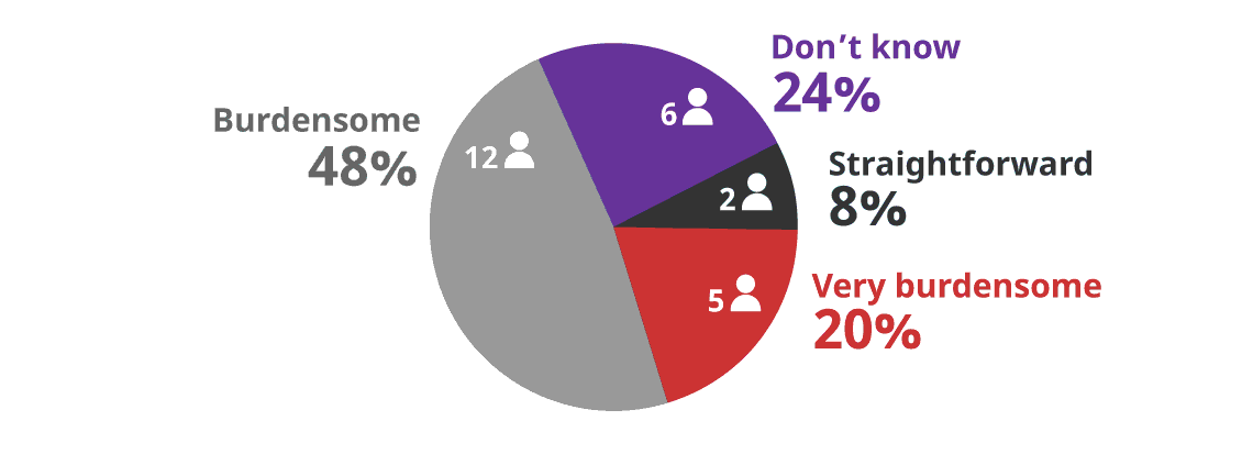
- Straightforward = 8% (2)
- Burdensome = 48% (12)
- Very burdensome = 20% (5)
- Don’t know = 24% (6)
- Canada has addressed its space legislative requirements through incremental changes to existing legislation and by creating new laws to address specific areas of concern:
- Transport regulates space launch – Canadian Aeronautics Act (1985)
- ISED regulates spectrum for space – Radiocommunication Act (1985)
- CSA manages space R&D – Canadian Space Agency Act (1990)
- Global Affairs regulates remote sensing from space – Remote Sensing Space Systems Act (RSSSA) (2005)
As a result, Canada has a patchwork of legislation that applies to various aspects of space-related activities. A General Space Act for Canada could consolidate all Canadian space law in a single, cohesive piece of legislation.
Do you believe Canada needs a comprehensive General Space Act?
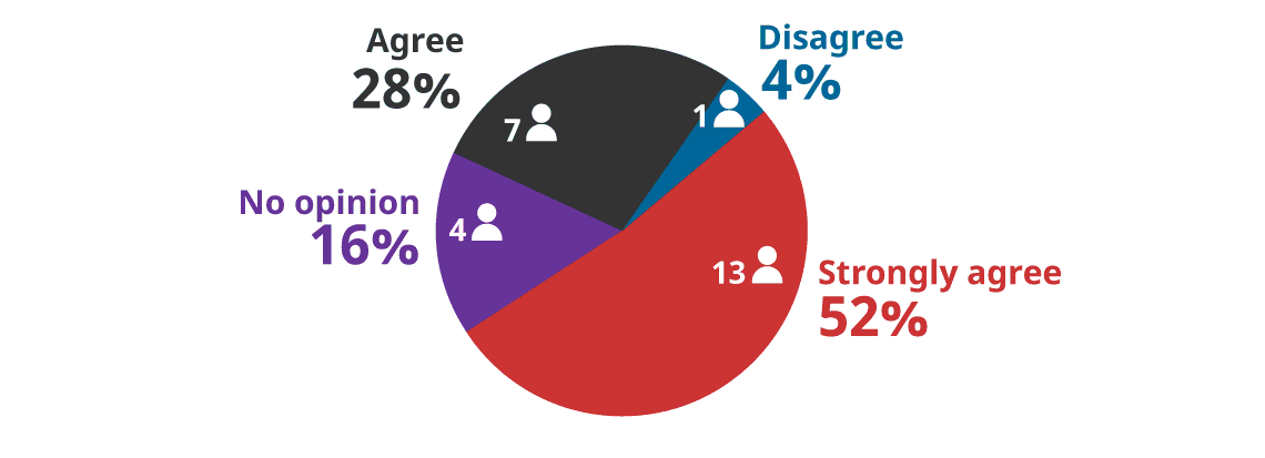
- In your opinion, what should be the primary goals of a General Space Act for Canada?
18 Free Text Responses (not reproduced here to preserve stakeholder anonymity)
- Do you believe Canada needs a national space policy, approved at the highest levels of government, to guide officials (e.g. RSSSA licencing officers) and others as they balance various, sometimes competing, Government goals in space (e.g. protecting national security, promoting economic development, enabling research and development, etc.)

- In your opinion, what should be the primary goals of a national space policy for Canada?
18 Free Text Responses (not reproduced here to preserve stakeholder anonymity)
- Please provide any additional comments you may have concerning the RSSSA, or any issues cited above. If you wish, more extensive input can be emailed to the review team at: rsssa@sscl.solutions
3 Free Text Responses (not reproduced here to preserve stakeholder anonymity)
Section 9 - Follow on communication with the Independent Review team
If you wish, you may email additional comments or submissions on any topic related to the Independent Review of the RSSSA to the review team at this address: rsssa@sscl.solutions
- Are you interested in being interviewed by the review team?
- No 4
- I'm willing to be interviewed if the team has additional questions for me 26
- I have additional comments that I would like to provide via an interview 7
- Please provide your contact information if you would like to discuss additional comments or submissions on any topic related to the review of the RSSSA with the Independent Review team
- 27 Free Text Responses (not reproduced here to preserve stakeholder anonymity)
Annex B - Technology Trends for Earth Observation
It is a key theme of this Independent Review of the RSSSA that ongoing changes in Earth observation technology are having a significant impact on how the Act should be implemented in the near term and possibly amended in the future.
For background information, this annex gives an overview of important technology development trends that will apply to Earth observation systems in the near term (1-5 years) and long term (20 years), with potential effects on the operation of RSSSA to be determined.
We use Technology Readiness Levels (TRL) as a method for describing the estimated maturity of the listed technologies. TRLs are a standardized descriptive tool used to characterize technologies during the pre-commercial development of a product. Footnote 52
Timeline Technology Key Impact TRL Next five years Multi-frequency SAR Allows operators to change remote sensing frequencies by sending a command to the satellite. 5 Low-Frequency SAR (P- and L-bands) Ability to detect underground rivers; high penetration ability. 9 High-Frequency SAR (Ku- and Ka-bands) Provides high-resolution SAR images. Useful in glaciology. 9 Bistatic Radar Enhanced radio cross-section of a target; ability to detect stealth aircraft; small satellites can operate with a radar receiver; reliant on scattering from external radio signals. 9 Space-Based Hyperspectral Imaging High spectral resolution. Multiple spectral bands for data exploitation. 7 Thermal Infrared Cameras Ability to detect thermal signatures on the Earth’s surface. 9 Small Satellite Bus Low cost, short lead time, low failure impact, adaptable to space-grade commercial-off-the-shelf (COTS) components, agile, more launch options. 9 Flexible Solar Panels Adhere to complex spacecraft shapes, reduce installation cost, thin, lightweight, and cheaper (less material). 3 GNSS Onboard orbit determination with great precision, independent of ground stations, improving mission logistics and navigation for terrestrial systems. 9 Micro-Electro-Mechanical Systems Diverse applications, reduced physical size, volume, weight and cost, and unique devices and components. 9 Patch Antenna Highly directional, small size, and ease of mounting due to their flatness. 9 Monopropellant Cheapest propulsion system available. Consumes little energy from the spacecraft. Easy to manufacture. 9 Phased Arrays Electronic Steering, which translates to faster antenna tracking. Low maintenance cost. 9 Optical Communications Secure communication, high data rates, and long-distance connectivity. 9 Cloud-Based Computing Users harness the use of supercomputers for data processing and exploitation without purchasing an in-house product. 9 Open-Source Data Democratization of data enables users to obtain EO data freely. 9 Commercial services Greater availability of commercial ground stations. Users can obtain a refined product with detailed information. 9 Archival Data Analyzes trends and change detection from an area of interest. Provides the training dataset to AI. 9 Big Data Analytics Enables automation and increased speed in image analysis and interpretation. Algorithms can “learn” how to interpret the data. Ability to identify anomalies missed by human interpreters. 9 All-Source Users can gather information from sources other than SAR and Optical sensors. 9 Micro-Opto-Electro-Mechanical Systems Miniaturized size; programmable; electrostatically steerable (as opposed to mechanically steerable). 4 Next two decades Distributed Computing Decentralizes tasks by sharing the algorithms and the datasets to multiple computers. 7 Optronic Synthetic Aperture processor Renders the ability for spacecraft to do onboard image processing at a fraction of the time from traditional processing technologies. 2 Pump Fluid Loop High thermal regulation capabilities (wide range of temperatures), ability to re-distribute the waste heat to heat up cold components during cold conditions and reject heat during hot conditions. 9 Electric Propulsion High fuel efficiency (very high specific impulse), small footprint and lighter owing mainly to a much smaller propellant reservoir and large velocity change while consuming a small amount of propellant. 6 Synthetic Aperture LIDAR Ability to create detailed images using an onboard laser. Greater detail than SAR. 3 Inflatable Antenna Low complexity compared to other deployable antennas, high packing efficiency, lightweight, high scalability 7 Regenerative Fuel Cells Low weight and volume, potential to have a lower cost, free from self-discharge, high specific energy. 2 Annex C - Existing and Near-term Earth Observation Systems
The large number of existing and soon-to-be launched Earth observations systems is an important factor in assessing the utility of the RSSSA.
For background information, the following table lists publicly-announced existing and near-term Earth observation systems.
The table headers are defined as follows:
- Civil/Commercial: Mission’s applicable area
- Country of Origin: Country where the satellite has been designed and manufactured
- Launch Date: Date on which the satellite has been launched
- Size: What is the satellite’s mass
- Large: >1,000 kg
- Medium: 500-1,000 kg
- Mini: 100-500 kg
- Micro:10-100 kg
- Nano:
- Data Provider
- Value Added Information Provider
- Taskability (Can the system be tasked on short notice to image specific areas or is the image collection plan automatic and fixed?)
- Cloud Storage/Retrieval
- Actual vs Planned Number of Satellites by 2026
- Free, Open
- Commercial Cost
- Latency and Access Issues (Real Time, Near Real Time (NRT) or not; Limited; etc.)
- Frequency
- Swath Width
- Maximum Resolution
- Operating Mode:
- Polarimetric
- Interferometric
- Strip or Spot Mode
- Active or Passive
- Pushbroom or Whiskbroom
- Maritime= Maritime Surveillance (e.g., ship detection & tracking, fisheries enforcement, oil spill detection)
- Ice= Ice Monitoring
- Ocean=Oceanography (e.g., winds, waves, ocean colour)
- Agriculture =Agriculture (e.g., crop detection, yield & health monitoring, soils)
- Forestry =Forestry (e.g., type, health, biomass)
- Disaster =Disaster response
- Mapping =Mapping (e.g., topographic, land use)
- Hydrology=Hydrology (Flooding, Shorelines, Snow water equivalent)
- Glaciology =Glaciology
1
RCM (GoC)
